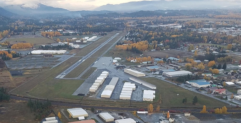
Sandpoint Airport
Airport information may not be current and should not be used for navigation.
Location:
Sandpoint Airport
1101 Airport Way
Sandpoint, ID 83864
Phone Number: 208-265-2266
Airport Weather: 208-263-3074
Airport Manager
Dave Schuck
Email: dave.schuck@bonnercountyid.gov
Airport Maintenance
Dale Lockwood
Email: dale.lockwood@bonnercountyid.gov
Bonner County will soon be accepting proposals to lease lots for hangar construction at Sandpoint Airport. Please see the individual Requests for Proposal (RFP) below when they are posted.

Airport Operations
| FAA Identifier: | SZT |
| Lat/Long: | 48-17-58.3620N / 116-33-36.4860W 48-17.972700N / 116-33.608100W 48.2995450 / -116.5601350 (estimated) |
| Elevation: | 2131 ft./650m (estimated) |
| Variation: | 18E (1995) |
| From City: | 2 miles N of Sandpoint, ID |
| Zip Code: | 83864 |
| Airport Use: | Open to the Public |
| Sectional Chart: | Great Falls |
| Control Tower: | No |
| ARTCC: | Seattle Center |
| FSS: | Boise Flight Service Station (1-800-WX-BRIEF) |
| NOTAMs Facility: | SZT (NOTAM-D service available) |
| Attendance: | Summer 0700-1900, Winter 0800-1700 |
| Wind Indicator: | Lighted |
| Segmented Circle: | Yes |
| Lights: | Dusk-Dawn ACTVT MIRL RY 02/20 AND PAPI & REIL RYS 02 & 20 – CTAF. |
| Beacon: | White-Green (Lighted Land Airport) |
Airport Communications
| CTAF/UNICOM: | 122.7 |
| WX AWOS-3: | 135.425 (208-263-3074) |
APCH/DEP SVCS PRVDD BY SEATTLE ARTCC FREQS 123.95/282.3 (LAKESIDE RCAG.)
Airport Services
| Fuel Available: | 100LL JET-A |
| Parking: | Tiedowns: $6 per night, $30 per month |
| Airframe Service: | Major |
| Powerplant Service: | Major |
| Bottled Oxygen: | None |
| Bulk Oxygen: | None |
Runway Information
| Dimensions: | 5501 x 75 ft./1677 x 23m | |
| Surface: | Asphalt, in good condition | |
| Weight Bearing Capacity: | Single Wheel | 40,000 lbs |
| Runway Edge Lights: | Medium Intensity | |
| Runway 2 | Runway 20 | |
| Latitude: | 48-17.589630N | 48-18.355743N |
| Longitude: | 116-33.968497W | 116-33.247630W |
| Elevation: | 2131 ft. | 2131 ft. |
| Gradient: | 0.1 | 0.1 |
| Traffic Pattern: | Left | Left |
| Runway Heading: | 014 magnetic. 032 true | 194 magnetic, 212 true |
| Markings: | nonprecision, in good condition | nonprecision, in good condition |
| Visual Slope Indicator: | 2-light PAPI on left (3.75 degrees glide path) | 2-light PAPI on left (3.75 degrees glide path) |
| Runway End Identifier Lights: | No | Yes |
| Touchdown Point: | Yes, no lights | Yes, no lights |
| Instrument Approach: | LOC/DME | |
| Obstructions: | 23 ft. rr, 680 ft. from runway, 170 ft. left of centerline, 20:1 slope to clear | |
Airport Operational Statistics
| Aircraft Based on the Field: | 99 | Aircraft Operations: avg 83/day | |
| Single Engine Airplane: | 85 | 64% | Transit general aviation |
| Multi Engine Airplanes: | 8 | 33% | Local general aviation |
| Jet Airplanes: | 2 | 3% | Air taxi |
| Helicopters: | 3 | ||
| Gliders Airplanes: | 1 | ||
Useful Web Links
| Federal Aviation Agency | www.Faa.gov |
| Airports | www.Airnav.com |
| Kodiak Aircraft Company | www.kodiak.aero |
| Sandpoint Info | www.Sandpoint.com |
| FBO | www.granite-aviation.com |