Priest River Airport
*** NOTICE ***
*** DATE CHANGE ***
RUNWAY CLOSURE
PRIEST RIVER AIRPORT
1S6
RUNWAY CLOSED FOR MAINTENANCE
JULY 20 to 31, 2026
AND
SEPTEMBER 15 to 16, 2026

Airport information may not be current and should not be used for navigation.
Location:
Priest River Airport
102 Airfield Way
Priest River, ID 83856
Phone Number: 208-265-2266
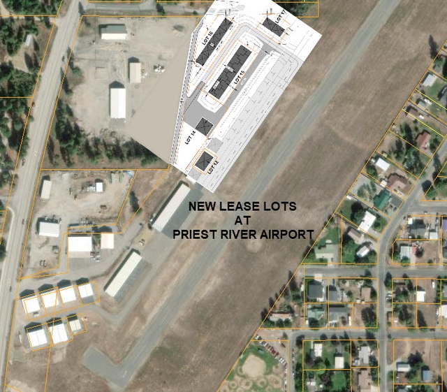
Bonner County will soon be accepting proposals to lease lots for hangar construction at Priest River Airport. Please see the individual Requests for Proposal (RFP) below when they are posted.
Airport Manager
Dave Schuck
Email: dave.schuck@bonnercountyid.gov
208-265-2266
Airport Maintenance
Dale Lockwood
Email: dale.lockwood@bonnercountyid.gov
208-265-2266
Master Plan for the Priest River Airport
- Priest-River-Airport-Master-Plan
- Cover-and-Table-of-Contents
- Chapter-1-Introduction
- Chapter-2-Inventory
- Chapter-3-Forecast
- Chapter-4-Facility-Requirements
- Chapter-5-Alternatives-Analysis
- Chapter-6-Capital-Improvement-Program
- Chapter-7-Land-Use
- Chapter-8-Airport-Layout-Plan-Description
- Appendices
Airport Operations
| Lat/Long: | N48°11.44′ / W116°54.59′ |
| Elevation: | 2187 feet MSL ( Estimated) |
| Variation: | 1985 is 19° East |
| From city: | 01 miles N of Priest River, ID |
| Zip code: | 83856 |
| Airport use: | Open to the public |
| Activation Date: | October 1945 |
| Control tower: | No |
| ARTCC: | Seattle Center |
| FSS: | Boise Flight Service Station (1-800-WX-BRIEF) |
| NOTAMs Facility: | BOI (NOTAM-D service available) |
| Attendance: | Unattended |
| Wind Indicator: | Yes, lighted |
| Segmented Circle: | No |
| Lights: | SEE RMK |
| Beacon: | None |
| Sectional Charts: | Great Fall, Seattle |
| Airspace Analysis: | Established prior to 15 May 59' |
Airport Communications
| CTAF/UNICOM: | 122.900 |
| AWOS-3 at SZT (15.5 NE): | 135.425 208-263-3074 |
| AWOS-3 at COE (25.3 S): | 135.075 208-772-8215 |
| ATIS at SFF (34.7 SW): | 120.55 |
Airport Services:
| Fuel Available: | None |
| Transient Storage | Tiedowns / chains removed during winter |
| Airframe Repair: | None |
| Engine Repair: | None |
| Bottled Oxygen: | None |
| Bulk Oxygen: | None |
| Couresy Car: | Available |
Runway Information
| Dimensions: | 2950x48 | |
| Surface: | Asphalt, in good condition | |
| Weight Limits: | S-12 | |
| Runway Edge Lights: | Non- Standard RY 01 LIRL UNLGTD First 200 feet | |
| Runway 1 | Runway 19 | |
| Latitude: | N48°11.24′ | N48°11.64′ |
| Longitude: | W116°54.80′ | W116°54.38′ |
| Elevation: | ||
| Gradient: | 0.1 | 0.1 |
| Traffic Pattern: | Left | Left |
| Markings: | Basic, in fair condition | Basic, in fair condition |
| Obstacles: | 80 ft trees 1000 feet from runway | 75 ft trees 650 feet from the runway 150 ft left of center |
Nearby Navigation Aids
| ID | Name | Frequency | Radial | Range |
| COE | Coeur d' Alene | 108.8 | 332 | 25.30 |
| SKA | Fairchild | 111.4 | 024 | 46.20 |
| GEG | Spokane | 115.5 | 016 | 47.40 |
| MLP | Mullan | 117.8 | 296 | 67.50 |
| SZT | Sandpoint | 264 | 047 | 15.10 |
| DPY | Deer Park | 365 | 218 | 24.70 |
| LEN | Post Falls | 345 | 165 | 27.00 |
| ION | Ione | 279 | 308 | 37.10 |
Useful Web Links
| Federal Aviation Agency | www.faa.gov |
| Airports | www.airnav.com |
| Priest River Info | www.priestriverchamber.com |