Road Projects 2024
Paving Projects:
E Dufort Rd x Old Highway 95 - To begin Wednesday, June 26th from 8:00am - 9:00am. Complete
Sunnyside Rd - Paving will begin Tuesday, July 30th. Complete
Nagle Rd - Thursday, September 26th 2024 and Friday, September 27th, 2024 Complete
S Center Valley - Beginning at the Selle Rd intersection headed north 2000 ft. October 2024. Complete
In Blanchard - The road aprons of the following roads will be paved on July, 25th and 26th: Complete
- Both ends of Rusho Ln
- Railroad Ave at Blanchaard-Elk Rd
- Geaudreau Ln at Hwy 41
- Blanchard Cutoff at Hwy 41
- Both ends of Poirier Bridge
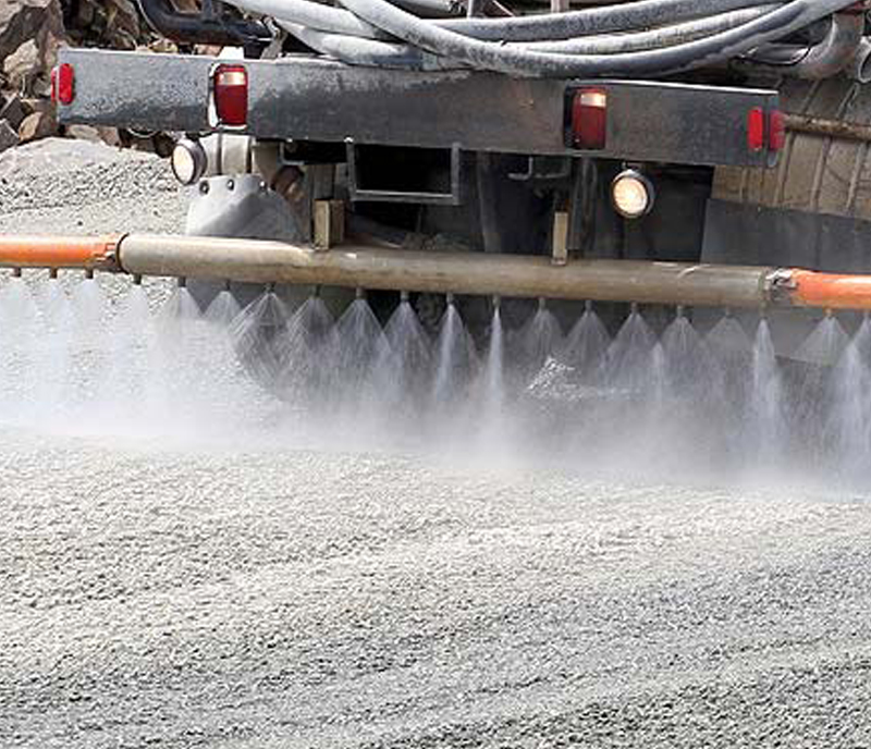
Magnesium Chloride: Complete
All Districts have completed their applications of Dust Abatement for 2024.
Chip Seal Projects: Complete
Chip Sealing will begin in District 3 (Sandpoint area) starting Monday, August 5th, 2024: DISTRICT COMPLETE
- Whiskey Jack Rd
- Red Clover Dr
- Red Clover Circle
- Nancy Rd
- Crooked Ear Dr
- Shingle Mill Rd (Tuesday, August 6th, 2024)
- Jacobson Rd (Tuesday, August 6th, 2024)
- Selle Rd (Wednesday, August 7th and Monday, August 12th)
- W Pine St (Tuesday, August 13th)
- Pinecrest Rd (Tuesday, August 13th)
- Pinecrest Loop (Tuesday, August 13th)
- Upland Dr (Wednesday, August 14th)
- Gooby Rd (Wednesday, August 14th)
- Sweetwater Dr (Thursday, August 15th)
- Baldy Mountain Rd (Thursday, August 15th)
Chip Sealing will begin in District 2 (Priest Lake and Priest River) starting July 18th, 2024: DISTRICT COMPLETE
- Reeder Bay Rd
- Kalispell Bay Rd
- West Lakeshore Rd
- Luby Bay Rd
- Fairway Dr
- Long Dr
- North and South Ryan Rd
- Tracy Ln
- Courtlen Ct
- Jacob Dr
- Squaw Valley
- Peterson Rd
- Bear Paw Rd
Chip Sealing will begin in District 1 (south of the Long Bridge) starting July 8th, 2024: DISTRICT COMPLETE
- Ferry Rd
- Old Highway 95
- Algoma Spur Rd
- S Sagle Rd
- Gallop Circle Rd
- Horizon Dr
- E Dufort Rd
- Comeback Bay Rd and E Comeback Bay Rd
- Gold Mountain Dr
- Spades Rd and Schell Rd
.png)
Bridge Projects:
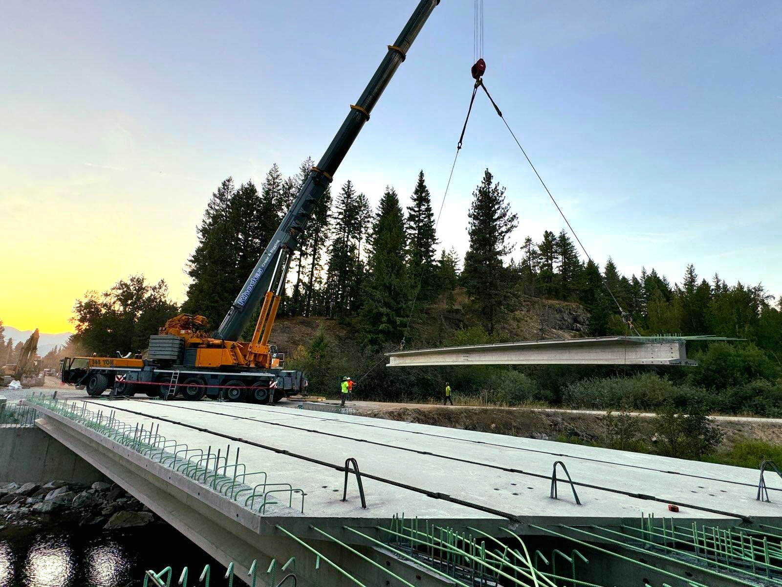
Grouse Creek Bridge - Full bridge replacement, currently under construction between Grouse Creek Cutoff and Samuels Rd. Expected to be completed fall 2024. (Depicted)
Rapid Lightning Bridge #5 - Construction begins next week (Monday, June 17th). This will be a 2 year project near the 5900 block of Rapid Lightning Rd. We will be working on the bridge one lane at a time; as such there will only be a single lane for traffic.
Expect delays. The bridge will be kept open most of the time but may need to be entirely closed for construction, in those cases detour routes will be in place. 11/8/24 UPDATE: Both lanes will be open for the winter months with speed restrictions in place. Use caution.
Eastriver Loop - Currently under design stage.
Colburn Culver Over Grouse Creek - Construction to begin 2025
Colburn Culver Over Pack River (north end) - Construction to being 2025 or beyond.
Rapid Lightning Bridge #4 - Construction to bein 2025 or beyond.
Eastshore Rd Over Hunt Creek - Construction to being 2026 or beyond.
Merrit Bridge - Pilling Wrap Repair and Deck Epoxy 2028 or beyond.
Other Projects:
Kooteni Bay Rd - Updates will be made to the median the delineators will be upgraded to jersey barriers starting 9/23/24. Complete
Striping Projects:
.png)
Culvert Projects:
Edgemere Cutoff - On Tuesday, August 13th, 2024 a portion of will be closed from Spirit Lake Cutoff to the railroad tracks for a culvert replacement. Complete
Wrenco Loop - On Tuesday, August 20th and Wednesday August 21st Wrenco Loop will be temporarily closed to through traffic near the 3100 block due to a culvert replacement. Please use an alternate route. Complete
Eastriver Rd - On Wednesday. August 28th Eastriver Rd will be temporarily closed due to a culvert replacement at Chase Creek (near the 13700 block). Complete
Woodland Dr - Starting Tuesday, September 3rd Woodland Dr will be closed at the 500 block for 3-4 days. We will have message boards out to notify the public in advance. Complete
Forest Siding Rd and South Center Valley Rd - Expect delays on Forest Siding Rd and South Center Valley Rd on Thursday, September 12th due to a culvert replacement. Delays could potentially be up to 1 hour. Complete
Garfield Bay Rd (900 Block) - Starting the week of September 16th Garfield Bay Rd will be closed at the 900 Block to through traffic for a culvert repair. Reader boards and detour routes will be in place to redirect via Garfield Bay Cutoff. Complete
S Center Valley Rd - We will be closing S Center Valley Rd near the 1860 Block from Monday, September 23rd until 4:00pm Tuesday, September 24th for a deep culvert replacement. Complete
Garfield Bay Rd - On Wednesday, September 25th, Thursday, September 26th and Monday, September 30th Garfield Bay Rd will be closed from 7am - 3pm from the beginning of the road down to the 900 Block due to culvert replacements.
Center Valley Rd - We will be closing Center Valley Rd at the 1600 block to the 2000 block starting Monday, September 30th through Thursday, October 3rd for 3 deep culvert replacements. Complete
Dufort Rd culvert at Moore Creek - We have heard from the Contractors on the Dufort Rd Culvert Replacement Project and they said that at this point, due to the weather delaying the project, they will not be able to open the road any sooner than 11.27.24.
Reroutes through Lakeshore Dr will still be in place. Complete
.png)
Gypsy Bay Bridge Closure starting Monday, Sept 28th
The bridge at the 2040 blk of Gypsy Bay Rd will be closed from Monday, Sept 28th to approximately Oct 10th for a rebuild. Please use Moonshadow Rd for the detour.
Paving on N Kootenai Rd from the intersection of Firestone Ln to Selle Rd. Starting Monday, Sept 28th.
Paving will start on N Kootenai Rd from the intersection of Firestone Ln to Selle Rd on Monday Sept 28th. The project will take approximately one week. Please expect delays.
Road Closure Notice
Helen Thompson Rd will be closed on Sept 16th @ Johnsons Creek from 7:30 am to noon
W Shingle Mill Rd will be closed on Sept 17th at approximately 100' south of Bobtail Rd from 8am to 4pm. Both for culvert replacements.
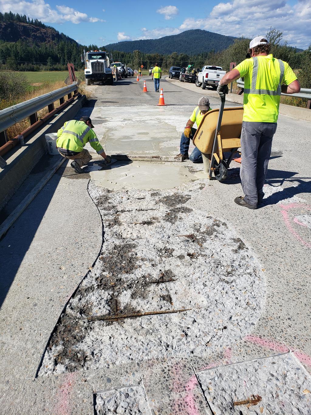
UPDATE 9/02/2020 - MCABEE FALLS BRIDGE WORK UNDERWAY - CREWS ARE REPAIRING THE DELAMINATED CONCRETE BRIDGE DECK WITH GROUT IN PREPARATION OF APPLYING AN EPOXY SEAL OVER THE ENTIRE BRIDGE DECK.
UPDATE 8/12/2020 - RAPID LIGHTNING BRIDGE #5 REPLACEMENT PROJECT DESIGN OPTIONS
THIS BRIDGE REPLACEMENT PROJECT IN THE 5900 BLOCK OF RAPID LIGHTNING ROAD IS PLANNED TO BE COMPLETED IN THE NEXT 6 YEARS, BUT THE CONSTRUCTION DESIGN OPTION NEEDS TO BE SELECTED WITHIN THE NEXT MONTH. THE PROJECT IS PLANNED TO BE COMPLETED IN 2026 WHEN IDAHO DEPARTMENT OF TRANSPORTATION HAS IT SLOTTED FOR FUNDING, UNLESS FUNDING COMES AVAILABLE SOONER. THE WORK WILL BE CONTRACTED OUT AND THE CONSTRUCTION TIME FRAME IS MAY THROUGH OCTOBER IN YEAR OF CONSTRUCTION (TO BE DETERMINED). PUBLIC COMMENT MAY BE MADE TO THE ROAD AND BRIDGE OFFICE IN WRITING OR VIA EMAIL TO MATT.MULDER@BONNERCOUNTYID.GOV OR STEVE.KLATT@BONNERCOUNTYID.GOV.
SEE IMAGES BELOW FOR EACH OF THE 3 OPTIONS.
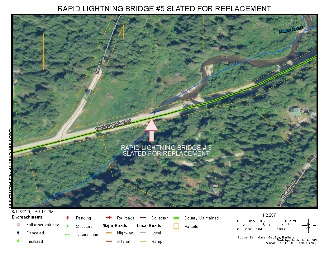
OPTION 1 - BONNER COUNTY ROAD DEPARTMENT *PREFERRED OPTION DUE TO COST - CLOSE ONE LANE TO BUILD HALF OF THE NEW BRIDGE THEN USE NEW SECTION WHILE THE REMAINING BRIDGE LANE IS BUILT. INCLUDES A TEMPORARY TRAFFIC SIGNAL AT EACH END OF CONSTRUCTION ZONE FOR 1 LANE TRAFFIC. WITH APPROXIMATELY A 3 MINUTE WAIT FOR ALTERNATE LANE OF TRAFFIC TO PROCEED THROUGH THE CONSTRUCTION ZONE.
OPTION 2 - NORTH ROUTE BUILD, KEEPING EXISTING BRIDGE AND ROAD OPEN DURING CONSTRUCTION OF NEW ROAD AND BRIDGE. - RESULTS IN 25% INCREASE IN COST OVER OPTION 1 DUE TO STREAM BED RELOCATION, BUILDING OF NEW ROAD BED AND INCREASED RIGHT OF WAY PURCHASE.
OPTION 3 - SOUTH ROUTE BUILD, KEEPING EXISTING BRIDGE AND ROAD OPEN DURING CONSTRUCTION OF NEW ROAD AND BRIDGE. - RESULTS IN 20% INCREASE IN COST OVER OPTION 1 DUE TO BUILDING OF NEW ROAD BED AND INCREASED RIGHT OF WAY PURCHASE.
Update 7/23/2020 - Our crews are busy rebuilding and resurfacing roads throughout the County this summer. Chipseal application continues in District 1 in the Blanchard area next week. Wooded Acres Drive is slated for BST application in mid to late August. Chip sealing equipment is shared by the three road districts and goes to District 2 following repairs. District 2 roads to be done include E and W Cedar Ln, Eastshore Rd, Freeman Lake Rd, Hoodoo Loop, Hoop Loop and LeClerc Rd. District 3 will follow with River Rd, Lightning Creek Rd, East Spring Creek Rd, River Lake and N River Lake Dr.
7/01/2020 Message from Steve Klatt, Director, Road and Bridge Department
Reflections – Summer 2020
The past three months have been a most interesting time in the life of the Bonner County Road Department. Mid-March found us shuffling half crews on and off for the next six weeks, during which our summer construction schedule began to slip immediately. By the time we got our full crews working together again, Mother Nature decided to play pranks upon us with frequent and persistent rain events. Now, at the end of June, we are finishing our mag chloride treatments of early June.
The interruptions and rain delays have also upended our construction schedules for this year. We have been able to get a substantial amount of work done on North Kootenai Road, brushing work done up on Eastshore Road at Priest Lake, and several smaller roads graveled near Cocolalla Lake that have been waiting a few years. A project impacted by this year’s interruptions has been our BST project for Lakeshore Drive being split into road improvements later this year and surface treatment being completed next summer.
Chip sealing projects will get underway right after the Fourth in the Sagle area, move out to the Clark Fork area and then up to Priest Lake. Depending on what little tricks Mother Nature is hiding up her sleeves, we should be done with chips around the middle of August. We will have a crew working on brushing and ditches up Baldy Mountain Road, plus a contractor clearing right-of-way on Woodland Drive. We are working on setting up a guardrail project for an area on Denton Road and the striping of roads will get under contract before too much longer.
Bonner County got a unique opportunity to participate in planning efforts funded by the Federal Highway Administration to create a Local Roads Safety Plan. The numbers of serious and fatal crashes on local roads is disconcerting at best and I have wanted to study our crash data to determine if similarities in crashes exist that might be treated systemically for improved driver safety. This effort has been made a bit cumbersome by COVID 19 restrictions on travel this year, but getting traffic safety planners to help us analyze our road system is a good starting point. We have been awarded a grant for right-of-way clearing of hazard trees in a couple of years and that will help reduce the severity of future crashes.
We are working on a project to replace a small bridge that is failing out on the Gypsy Bay Road after summer traffic slows down and have a bridge deck restoration job scheduled up on Peninsula Road once we begin to have some warm days. There are three more intersection lights we will have installed on Highway 95 south of Sandpoint later this summer and will continue to expand our lighted intersection program each year. Hard to believe, but we are beginning to gather up our stockpiles of anti-skid material for winter already in a program that costs nearly $2 million each season. It has been good to add three new trucks to our aging fleet.
Let’s all drive safely and have patience with our crews working to improve your county roads.
Steve Klatt, Director
UPDATE 11/07/2019 DUFORT ROAD INTERSECTION WIDENING PROJECT HAS BEEN COMPLETED.
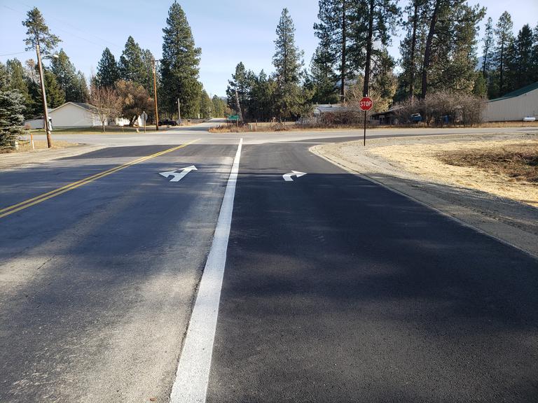
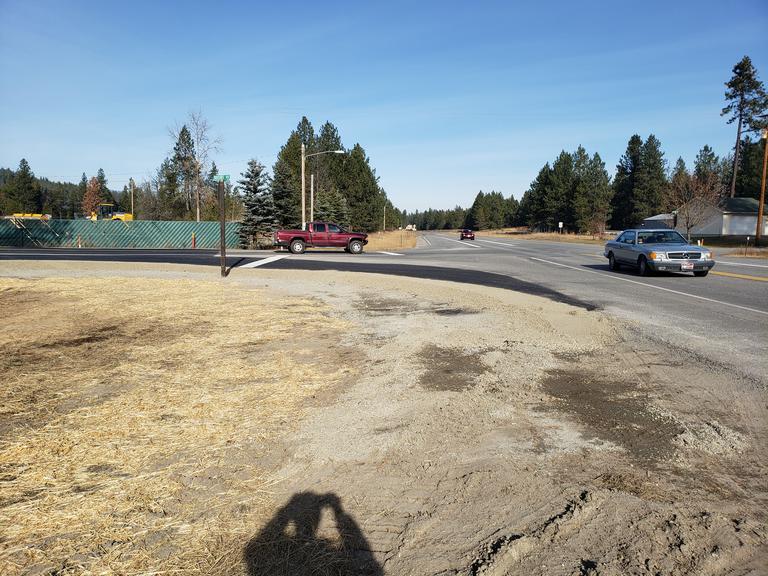
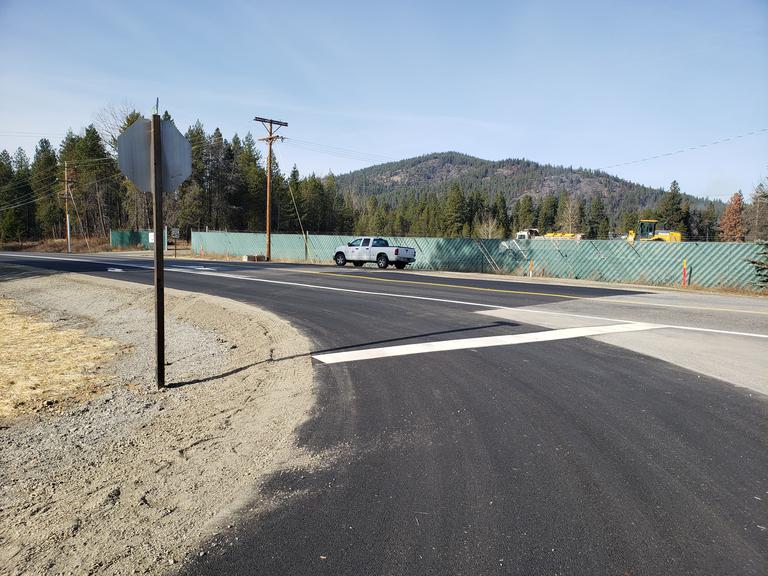
UPDATE 10/25/2019 - DUFORT ROAD INTERSECTION WIDENING PROJECT CONTINUES. PAVING IS PROJECTED TO TAKE PLACE NEXT THURSDAY, 10/31/2019.
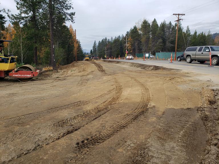
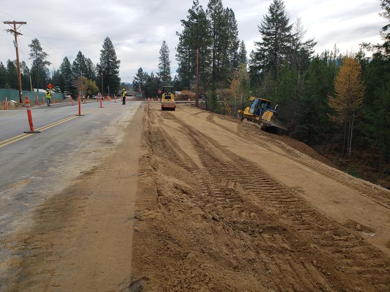
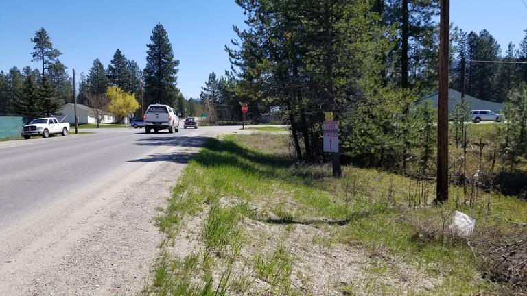
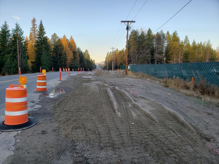
UPDATE 10/24/2019 - HIGHWAY 95 - DUFORT ROAD INTERSECTION TURN LANE ADDITION - WORK IS UNDERWAY ON THE TURN LANE ADDITION TO DUFORT ROAD AT HIGHWAY 95 INTERSECTION WITH MOST OF THE WORK SLATED TO BE COMPLETED IN THE NEXT WEEK OR TWO.
BEFORE
CURRENTLY WORK IS UNDERWAY
UPDATE 10/10/2019 - DICKENSHEET ROAD - NEW GUARDRAIL INSTALLATION COMPLETED
UPDATE 8/14/2019 - WOODED ACRES ROAD WILL BE CLOSED FOR MAINTENANCE FROM TUESDAY, AUGUST 20 THROUGH THURSDAY AUGUST 22. THE DETOUR VIA WESTWOOD HEIGHTS RD, LOWER MUSKRAT SPUR, MUSKRAT LAKE RD, GYPSY BAY RD TO LAKESHORE DRIVE WILL BE OPEN.
SEE DETOUR MAP BELOW: WOODED ACRES ROAD CLOSURE - DETOUR MAP.pdf
UPDATE 8/08/2019 - GROUSE CREEK BRIDGE REHABILITATION PROJECT BEGINS MONDAY, AUGUST 12TH.
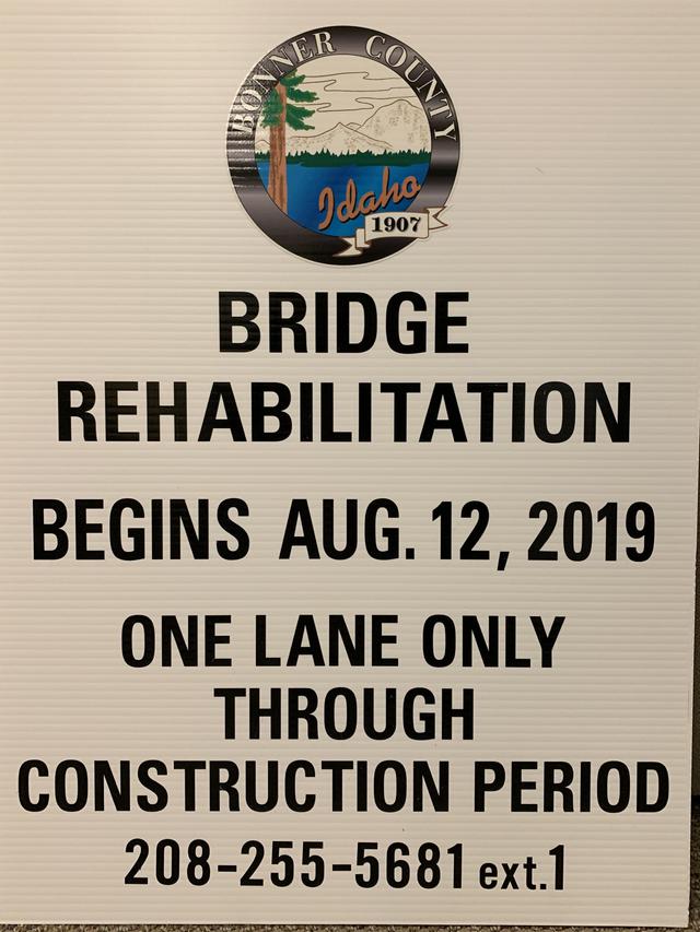
Expect delays as this project will be ongoing for a while. See map below:
UPDATE 8/08/2019 - CHIPSEALING PROJECTS IN DISTRICT 3 BEGIN NEXT WEEK
Upcoming chip seal projects in District 3 beginning Monday, August 12, 2019 are as follows:
1) Upper Pack River Rd 7.1 Miles
2) Elmira Rd .4 Miles
3) Samuels Rd 3.67 Miles
4) Grouse Creek Cutoff 1.2 Miles
5) Jacobson Rd 1.52 Miles
6) Lower Pack River Rd 3.03 Miles
Pilot cars will be leading traffic through, expect delays.
UPDATE 11/01/2018 - SUNNYSIDE ROAD WILL REOPEN TODAY BY 5 PM. THE ASPHALT PATCH WILL BE COMPLETED NEXT WEEK, WEATHER PERMITTING.
UPDATE 10/31/2018 - SUNNYSIDE RD - DAVIS SLOUGH CROSS-CULVERT INSTALLATION PROGRESS
This project is progressing nicely. The culvert is installed and compaction of fill is underway. Weather permitting, Sunnyside Road should be reopened Friday by 4 pm.
UPDATE 10/11/2018 - UPCOMING CLOSURE OF SUNNYSIDE RD AT MILE MARKER 1.7
FROM 8AM MONDAY, OCTOBER 29TH THRU FRIDAY NOVEMBER 2ND AT 4PM. ROAD CREWS WILL BE INSTALLING A HUGE CROSS CULVERT AT DAVIS SLOUGH. DETOUR WILL BE VIA THE EAST END OF SUNNYSIDE RD. (CREWS IMPROVED THE EAST END ROAD THIS PAST SUMMER.)
UPDATE 9/21/2018 - BOTTLE BAY INTERSECTION AT HIGHWAY 95 IS NOW OPEN
Bonner County Road & Bridge Director, Steve Klatt congratulates Randy McDougall of Earthworks Northwest on their substantial completion of the Bottle Bay Rd/ Highway 95 Intersection Safety Project. The intersection has been reopened.
UPDATE 9/07/2018 - BAYVIEW RD REBUILD PROJECT
Today, the contractor is working on Bayview Rd driveway transitions so property owners have quality access until the next phase of the road project is completed. Paving will begin Tuesday, September 18th and continue through September 23rd.
UPDATE 9/05/2018 BOTTLE BAY HIGHWAY 95 INTERSECTION PROJECT
Bike path tunnel assembled and back fill is still underway. The project adds a designated turn lane and widens the intersection in addition to moving the bike path. It was slated to be completed October 1st, but is expected to be finished later this month. The contractor is making good progress rebuilding the roadway. Paving, painting lanes and installation of guard rails will need to be completed prior to reopening the intersection.
VIEW FROM NORTH SIDE
VIEW OF GRAVITY WALL PRECAST BLOCK FROM SOUTH SIDE
PRECAST GRAVITY WALL BLOCK IS INSTALLED TO SUPPORT ROAD BED ON EACH SIDE
VIEW FROM JONES ROAD 9/05/2018
VIEW OF INTERSECTION FROM WEST SIDE OF HIGHWAY 95 8/29/2018
VIEW FROM NORTH SIDE 8/29/2018
UPDATE 9/05/2018 - SAGLE ROAD DITCHING AND BRUSHING - EXPECT 15 MIN DELAYS
BEGINNING 9/04/2018, ROAD CREWS WILL BE BRUSHING, DITCHING AND CLEANING THE RIGHT OF WAY ALONG SAGLE ROAD IN THE 2000 BLOCK NEAR GOLD MTN DR WORKING THEIR WAY EAST THROUGH EARLY OCTOBER. MONDAY - THURSDAY FROM 8 AM - 4 PM COMMUTERS CAN EXPECT 15 MINUTE DELAYS WITH PILOT CARS TAKING TRAFFIC THROUGH THE ACTIVE WORK AREA.
UPDATE 8/24/2018 BOTTLE BAY HIGHWAY 95 INTERSECTION PROJECT
Bike path tunnel assembled and back fill is underway. The project will add a designated turn lane and widen the intersection in addition to moving the bike path. It was slated to be completed October 1st, but is expected to be finished in mid to late September.
Views from North and South entrances of bike tunnel.
This project is funded by Local Highway Safety Improvement Program grant from LHTAC Local Hwy Technical Assistance Council.
The intersection was identified as highest priority as part of 2016 Bottle Bay Rd Safety Audit with 12 accidents and 1 fatality.
Update 8/14/2018 - Big Creek Bridge Project Progress
Big Creek Bridge summer long project in the 3700 block of Eastriver Rd is progressing nicely and scheduled to be finished by the end of August. The Kalispell Tribe, Idaho Fish and Game and USFS are funding the project to open another 10 miles of fish habitat that was previously impeded by the culvert under Eastriver Rd.
Update 8/06/2018 Bottle Bay Rd-Hwy 95 Intersection Project
Contractor begins assembling bike path tunnel. The intersection project is slated to be completed October 1st.
Upcoming Road Projects - Late July through Mid August
Careywood Area - Continued work to include widening the road bed and grinding the asphalt surface on Bayview Rd
Cocolalla Area - Rebuild - gravel Dogwood Ln, Pinewood Ln and Maplewood Ln
Sagle Area- Chip sealing Dufort Rd from Highway 95 to Ferry Rd
Carr Creek Area- Hauling gravel on Carr Creek Rd
Priest River Area - Replace culverts on Peninsula Rd and prep Spring Haven Dr and Merrit Ln and apply BST (hard surface material)
Ponder Point / Kootenai Area - Prep and Chip seal Ponder Point area County roads and Jeffery Dr
7/10/2018 UPDATES - CHIP SEALING PROJECTS - PONDER POINT ROADS AND JEFFREY DR.
Due to upcoming chip sealing projects, please note sign below.
The roads need to be completely dry, so please refrain from early morning watering and no parking on roads in Ponder Point area and also on Jeffrey Dr between July 16th - July 19th and also July 23rd - July 26th.
7/03/2018 Road Projects Underway
Big Creek Bridge project in the 3700 block of Eastriver Rd is underway with a temporary 1 lane bridge to detour traffic during the summer long project. The Kalispell Tribe, Idaho Fish and Game and USFS are funding the project to open another 10 miles of fish habitat that was previously impeded by the culvert under Eastriver Rd.
Temporary detour bridge
Original large culvert to be removed and replaced with a permanent 2 lane bridge to help facilitate fish travel along Big Creek.
Two smaller culverts to the right will divert the creek during construction of the new bridge.
6/28/2018 - Road Projects Underway
W Spring Creek Rd - Currently, County road crews are working on W Spring Creek Rd - brushing, ditching, widening, culvert installation and possible rock hauling. Monday - Thursday through July 19th.
Bayview Rd - Currently, County road crews are working on Bayview Rd - brushing, ditching, widening, culvert installation and possible rock hauling. Monday - Thursday through July 19th. In early August crews will begin grinding the existing asphalt and spreading it to widen the roadway. Hauling of 9" of base rock, and 6" of crushed rock will follow during the following weeks with the contractor scheduled to pave Bayview Rd the end of September.
6/27/2018 UPDATE - BOTTLE BAY RD - TRAINS BLOCKING RAILROAD CROSSING IN EXCESS OF 20 MINUTES
BURLINGTON NORTHERN SANTA FE RAILROAD
The number to call if a train is blocking the Bottle Bay Rd railroad crossing #058828R in excess of 20 minutes is 800-832-5452 BNSF DISPATCH
UPDATE 6/27/2018 - BOTTLE BAY INTERSECTION PROJECT UNDERWAY THROUGH OCTOBER 1ST
Bottle Bay Rd Intersection with Highway 95 will be closed for intersection reconstruction June 25 - October 1, 2018.
The safety grant project will create left and right turn lanes onto the highway and an underpass for the bike path.
The intersection will be closed for the duration of this project. The 3.1 mile long detour to Highway 95 will be via Lignite Road to Sagle Road.
See Map Below.
Update 7/11/2017 – Bottle Bay Rd

The contractor will continue paving Bottle Bay Road through the beginning of next week. Once the road surface is completed, they will be filling in the shoulders and driveway approaches in coming weeks.
5/11/2017 Update – Road Projects
Lakeshore Dr. culvert replacement May 15th
The BC Road Crew will be replacing a culvert at the 5000 blk of Lakeshore Dr on Monday, May 15th from 8 to 3, please expect delays up to 45 minutes.
Bottle Bay resurfacing project begins May 16th
Road construction will start on Bottle Bay Rd on Tuesday, May 16th for approximately 4 weeks. Please expect delays.
Cavanaugh Bay Road – Soldier Creek Culvert Replacement Project
Update 12/09/2016
Cavanaugh Bay Road opened to one lane traffic 12/08/2016. Crews continue to improve the road, so please drive with extreme caution.

Crews will be working as weather permits to restore both lanes. This section of road will be paved in the spring.

Cavanaugh Bay Road opened to one lane traffic 12/08/2016

12/09/2016 Culvert installation is complete and road building continues

12/05/2016 Fill, fabric and rock is being hauled in.
Update 11/29/2016
Crews will be building retaining walls, pouring concrete and compacting fill to secure the culvert in place before any road material will be added to rebuild the road. We are hoping to have Cavanaugh Bay Road open by December 5th. There will still be ongoing site work to ready the project for winter. Paving is planned in the spring of 2017.
Update 11/30/2016

11/30/2016 Crews work to evenly complete back fill and retaining wall securing culvert.

Soldier Creek flows freely through the new culvert.

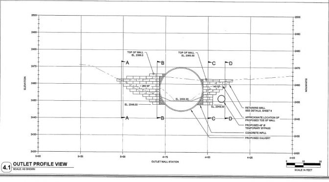
Design drawing showing block wall with geogrid strips and compacted back fill depth before regular fill goes in.

Backside of retaining wall with geogrid strips.

11/30/2016 View of culvert from Cavanaugh Bay Rd
Due to record rainfall this month, the contractor has pushed the opening date for the Soldier Creek Crossing on Cavanaugh Bay Road to December 5th. See link to map of detour route below.

Soldier Creek flows through new culvert

Sheet pile dam is removed to allow stream to flow


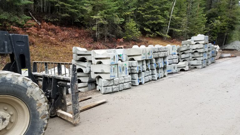
Retaining wall block is secured with 18′ strips of geogrid and compacted in 8′ depths and poured concrete to secure culvert in place.
Retaining wall block secures culvert in place, then fill will be added

Block with geogrid and compacted material between each strip
11/22/2016 More block to be set on sides to secure culvert before back filling begins

11/22/2016 Natural fill is placed inside the culvert for fish habitat

Culvert is built in place

Concrete is poured to secure culvert

Natural stream bed material will top the pit run and boulders to be placed in the culvert
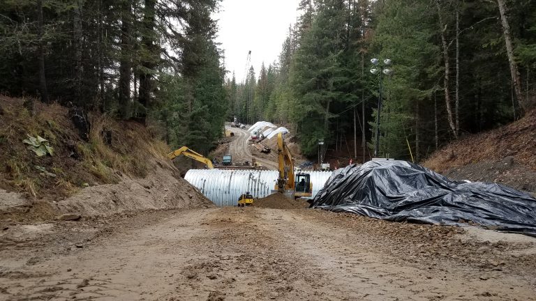
Culvert as is sits in the base at Soldier Creek.

Crews assemble the 25′ diameter culvert at Soldier Creek.

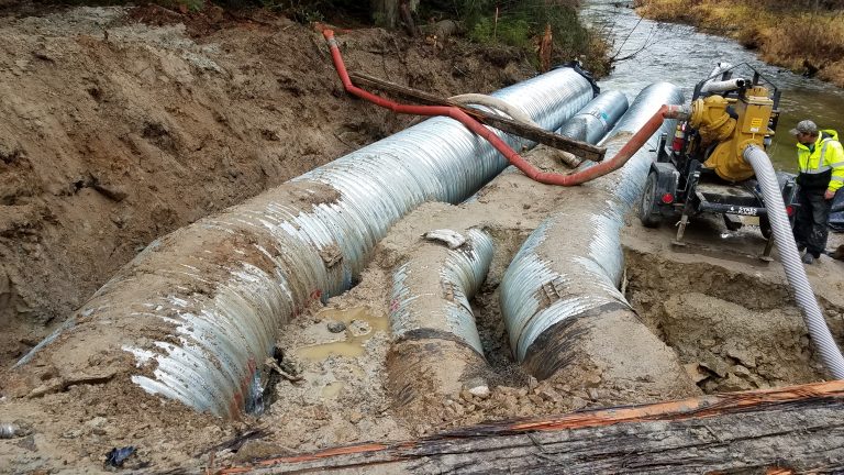
A 3rd diversion culvert- 5′ in diameter was installed to divert the heavy stream flow caused by record rainfall.

11/15/2016 Assembly of the 25′ diameter culvert begins.

Concrete and blocks form the base below the 25′ diameter culvert.

11/14/2016 Crews finally have a dry and stable rock base in the bottom of the excavation.
Update 11/09/2016
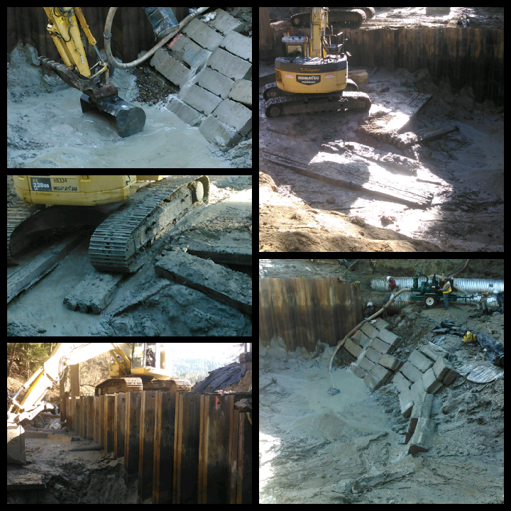
Workers continue preparation of the base for the new 25′ diameter culvert.

11/07/2016 Stream diversion measures and pumping finally work along with less rainfall to allow work on the Soldier Creek culvert replacement project to progress.
Update 11/02/2016
Update 10/31/2016
Unfortunately, heavy rain continues to hamper progress on the Soldier Creek culvert replacement project on Cavanaugh Bay Rd. According to NOAA weather statistics, October 2016 rainfall has already broken the 111 year record.

Whirlpool above intake culverts due to heavy rainfall

Heavy rainfall floods walking bridge across Soldier Creek

Water continues to flow around the sheet pile coffer dam on October 28th

A worker crosses the flooded foot bridge on October 28th

A pump has been added to divert more water from the job site

October 31st whirlpool above intake of bypass culverts
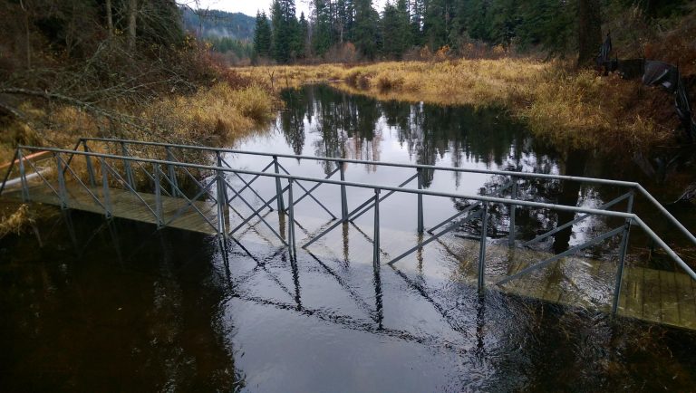
Creek level continues to rise with rainfall for the month of October 2016 breaking the 111 year record
UPDATE 10/25/2016
Due to record rainfall this month, the contractor has pushed the finish date for the Soldier Creek Crossing on Cavanaugh Bay Road to November 17th. See link to map of detour route below.

Original culvert

Soldier Creek 10/06/2016

Excavation down to top of old wooden culvert

Excavated material staged along Cavanaugh Bay Rd

Unearthing the original failing wooden culvert 10/13/2016

Building a temporary dam to divert stream during culvert replacement 10/13/2016
Construction of the culvert replacement on Cavanaugh Bay Rd at Soldier Creek has been delayed due to the weather and site conditions. The project was scheduled for October, which is typically a low water month with an average rainfall of 1.5”. Since construction began on October 10 th , we have had over 6” of rain, including one storm which qualified as a 3-yr storm event.

October 14th, unseasonably heavy rain floods temporary dam

Crews try to increase the temporary dam height efficiency
Because of the rain, the creek has risen from its typical 8” October depth to approximately 4ft deep. This has necessitated the installation of a second bypass pipe to handle the flows, as well as building the temporary coffer dam higher with ecoblocks and super sand bags. Even with these extra facilities, on two occasions the water has overtopped and undermined the coffer dam, sending water through the existing wooden structure once again. In one instance, it blew out a side of the cofferdam. It has become clear that the temporary ecoblock cofferdam is insufficient to block the flow of this quantity of water. Therefore, it was decided to install a sheet pile cofferdam which is taller and deeper and cannot be topped, undermined, or circumvented.

Heavy rain slows progress

Diversion culverts are almost at capacity 10/17/2016

Water level and flow increased by 10/21/2016

Stream diversion during project 10/21/2016

Sheet piles – interlocking 30′ sections to be driven 10′ into stream bed creating a coffer dam

Original structure exposed 10/24/2016
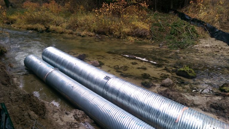
Downstream diversion 10/24/2016
The soils in the excavation limits are a silty sand for the first 15ft, and then transition to a blue clay at approximately creek level. The saturation of the soils in the work site has turned everything into a deep mud pit, with men and equipment unable move, let alone work effectively. To continue work, it was decided to import 6” minus rock and place it on top of geotextile fabric and geogrid to create a ramp and pads on which equipment can safely and effectively operate. It was also decided to continue the sheet pile wall the entire length of the new culvert so that the final excavation can be made without the sides slumping in – an event which would pose an extreme safety risk to workers 10ft below the water level.

Heavy rains cause new strategy for diverting water – building a coffer dam wall with 30′ sheet piles

Sheet pile driver
DETOUR ROUTE AROUND SOLDIER CREEK PROJECT
Please be advised of the upcoming road closure – Cavanaugh Bay Rd at Soldier Creek crossing for culvert replacement. Signs are posted at both ends of the closure. A primitive single lane 5 mile long detour road will be open during the road closure. Please note that this road will not be well suited to recreational vehicles and boat trailers, etc. Work is planned to be completed between October 3rd and November 17th.

August 1, 2016
Chip sealing projects are underway. Please drive with care and respect workers. We have a very limited (weather permitting) window to get these projects completed.


Crews are working in District 3 (Sandpoint area). Thank you for your patience.
Code of the West 2015 (A publication to help you better understand how things work in Bonner County.)

Bonner County is a wonderful place to live, work, and raise a family. We hope this information wil help enhance the quality of your life here. Respect your neighbors livelihood and property and be aware that your actions may have adverse impacts on your neighbors, human and otherwise. However, the information presented here is intended as a guideline and an introduction into some of the realities of rural living. You may discover other issues that may not have been covered by this document. We encourage you to research and examine all aspects of country living prior to surprises.
Bonner County elected officials, administration and staff pride themselves on their accessibility. By participating in the publication of the Code of the West, Bonner County is in no way divesting itself of its responsibility to its constituents. We offer this publication in the sincere hope that it will help you better understand how things work in Bonner County.
Images of the Old West draw people to an area once filled with miners, farmers, ranchers, loggers and other agricultural workers. Often newcomers are much more romantic about the West than the old timers and have false hopes about bringing their urban lifestyles into the great outdoors. They come with false expectations. They believe they can fax and email from the mountaintop. In the New West, the information superhighway is often a dirt road.
(for more information, click the link above)

12/21/2021
11/16/2021
.png)
Winter Update from our Director, Jason Topp
Hello Bonner County Drivers – It’s beginning to look like that time of year again. The recent rains have played havoc on some of our gravel roads. Grader operators are running hard to get these roads graded up before we have a big freeze to help alleviate the potholes going into winter. Snow is starting to fall and stick in the higher elevations; temperatures are dropping and some of the roads are starting to become slick. I hope most of you have installed your winter tires on your vehicles. It is the observation of the Road Department that there appears to be plenty of new residents in the county and that also means there will be plenty of people unfamiliar with Bonner County plowing protocols. Please remember that County roads are not maintained 24 hours a day, seven days a week and make sure you have good winter tires on your vehicles. Please be prepared for a steady routine of slippery roads.
Winter road maintenance is expensive, hazardous for operators and time consuming. Bonner County spent nearly $2,000,000 last winter providing safer roads. Snow plowing commences after several inches have accumulated on roadways. Bonner County Road & Bridge operates three districts to maintain around 700 miles of road, but all adhere to these priorities for our winter maintenance:
1st Priority School bus routes, arterials, and major collectors
2nd Priority All other county-maintained roads after 1st Priority roadways
3rd Priority Sanding generally begins after plowing a road is completed. Sand is applied to steeper roadway grades, at intersections, on bridges, and other areas determined to be hazardous. It is not standard policy to sand straight stretches of roadway because of snow floor. Road salt will be used along with sand in a few problem areas this year on our asphalt roadways only. This is new to Bonner County this year. We are very hopeful that this will help alleviate the amount of time we spend on these problem areas and make it safer for the traveling public.
Mailboxes in county road right-of-ways suffer greatly from snow plowing activity and are the responsibility of the owner. Most people underestimate the weight of snow being pushed from the road, so if you can wiggle your mailbox, there is a fair probability that plowed snow will take it down. County operators do not intentionally damage mailboxes but maintain speed to throw snow from the road. The growing number of garbage cans placed for pickup within the right of way must be kept out of the plowed travel surface because they will end up in the ditch and create an unsightly mess that individuals are responsible for.
Residents who remove snow from their driveways are reminded that Idaho Code 18-3906 prohibits placing snow or ice on any public road in a manner that impedes traffic or makes it unsafe and 18-3907 prohibits the placing of snow in any manner that affects the water flow of a ditch line. If your snow plowing affects the County’s plowing or anyone driving the road, you are breaking the law.
YOU CAN HELP
There are several ways the public can help make the County’s job more cost effective and safe:
• Vehicles must not be parked on roadways during snow events. Vehicles will be buried in the snow berm and/or towed if interfering with the plow route. Once the berm is in place, it is the resident’s responsibility to shovel their vehicle out. Please remember – our roads are not city streets!
• Landscape features such as rocks, fences or planters should be removed from the rights-of-way for the winter. They may be destroyed by snow plowing, but they can also do substantial damage to snowplows. Owners are responsible for County equipment that are unnecessarily damaged by these types of features.
• Do not push snow over ends of culverts or drainage structures. Rapid warming cycles in winter could result in overloaded ditches being unable to drain. Local flooding could occur.
• Mailboxes are damaged during snow removal operations. Replacement of damaged mailboxes is the responsibility of the property owner/resident per the Bonner County Road Standards Manual, Section 8.
• Snow removal operations require the use of large and heavy equipment during periods of darkness usually accompanied by limited visibility caused by falling snow. Bonner County operators are trained, and safety is always stressed. Drivers of automobiles should follow at a safe distance where the operator can see you in his mirrors.
• Children love to watch the large equipment, noise, lights, and the activity of snow removal operations. Try to remember the snow being thrown from the snowplows is very wet and heavy. Please keep children a safe distance away. The concentration required for snow removal, means the operators may not always be able to see people close by and accidents could result.
• Please encourage children NOT to build tunnels, forts or play in snow berms.
Information on the Road & Bridge website, https://www.bonnercountyid.gov/departments/roadbridge may help residents be proactive in securing their mailboxes and safeguarding articles placed in the County-Right-of-Way. We want everyone to have a safe and secure winter.
For further information, please call the Bonner County Road & Bridge Department at 208 255-5681, ext. 1; Monday through Friday, 7am to 4pm.
Jason Topp
Director
Bonner County Road & Bridge
10/28/21
Lakeshore Dr at Highway 95 will be closed on Wednesday, November 3rd from 6 am to 6 pm for a culvert replacement. Please use the detour route over Brisboy Rd. Detour signs will be posted in advance.
.png)
9/29/21
A letter from our Director, Steve Klatt
.png)
9/13/21
Congratulations to our Bonner County Road & Bridge Department employees Jonas Topp, Caiden Oliver, and Hannah Oliver for being the Bonner County Employees of the Month for July, August and September. 


.png)
7/16/21
Eastriver Road construction/closure schedule:
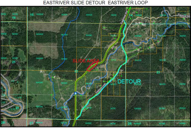
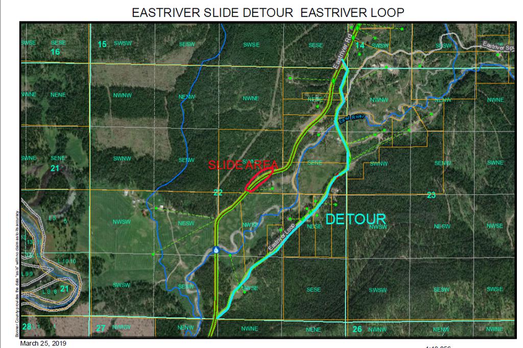
The Eastriver Road Slide Repair Project is slated to start on Monday, July 19th. The project will start at the 5000 block with flaggers and 1 way traffic through the 7000 block until it is complete. The Project is expected to be completed by October 1st.
August 2nd we will be closing Eastriver Road at 6500 block to through traffic from the south end of Eastriver Loop to the North end of Eastriver Loop. The Eastriver Loop road will be the detour route for the duration of the Project.
.png)
6/25/2021
Governor's visit to Lakeshore Drive - Highway 95 Intersection Improvement Project for 2022 made possible with Idaho's direct funding proposal
.png)
6/22/2021
.png)
BNSF will be closing the north end of Granite Loop Rd for railroad repairs on the following dates;
Wednesday, June 30th at 8 am, reopening on July 1st at approximately 4 pm
Friday, July 9th from 9 am to 4 pm
Notices will be put up this Friday.
4/19/2021
A note from the Director regarding Spring road conditions
3/15/2021
Changes to US-95 south of Sandpoint planned for 2021 and 2022
.png)
The Idaho Transportation Department is in the process of designing improvements to US-95 between Sagle and Sandpoint, with the first phase planned for construction this summer.
Click Here for the story
1/27/2021
Public Announcement - Heath Lake Road closure
1/13/2021
Thank you for your patience Bonner County Residents! We are out identifying issues and fixing them as fast as we can.
Here's a little of what we are dealing with.
1/8/2021 A message from Director Steve Klatt
12/28/2020 A Friendly Reminder
Please remember to give yourself and our plow/sander rigs a little extra space during this winter driving season.
.png)
11/09/2020 Message from Steve Klatt, Director, Road and Bridge Department
Hello Bonner County Drivers – It’s beginning to look like we may need to be ready for winter driving a bit earlier than usual this year and I hope most of you have gotten your winter tires on your rigs. Our observation in the Road Department is that there appear to be plenty of new residents in the county and that also means there will be plenty of people unfamiliar with Bonner County plowing protocols. Please remember that County roads are not maintained 24 hours a day, seven days a week and make sure you have good winter tires on your rig. Having just seen the local winter forecast for 12 feet of accumulated snowfall this coming winter, please be prepared for a steady routine of slippery roads.
Winter road maintenance is expensive, hazardous for operators and time consuming. Bonner County spent nearly $2,000,000 last winter providing safer roads. Snow plowing commences after several inches have accumulated on roadways. Bonner County Road & Bridge operates three districts to maintain 700 miles of road, but all adhere to these priorities for our winter maintenance:
1st Priority School bus routes, arterials and major collectors
2nd Priority All other county maintained roads after 1st Priority roadways
3rd Priority Sanding generally begins after plowing a road is completed. Sand is applied to steeper roadway grades, at intersections, on bridges, and other areas determined to be hazardous. It is not standard policy to sand straight stretches of roadway because of snow floor. Road salt is not used.
Mailboxes in county road rights-of-way suffer greatly from snow plowing activity and are the responsibility of the owner. Most people underestimate the weight of snow being pushed from the road, so if you can wiggle your mailbox, there is a fair probability that plowed snow will take it down. County operators do not intentionally damage mailboxes, but maintain speed to throw snow from the road. The growing number of garbage cans placed for pickup within the right of way must be kept out of the plowed travel surface because they will end up in the ditch and create an unsightly mess that individuals are responsible for.
Residents who remove snow from their driveways are reminded that Idaho Code 18-3906 prohibits placing snow or ice on any public road in a manner that impedes traffic or makes it unsafe and 18-3907 prohibits the placing of snow in any manner that affects the water flow of a ditch line. If your snow plowing affects the County’s plowing or anyone driving the road, you are breaking the law.
YOU CAN HELP
There are several ways the public can help make the County’s job more cost effective and safe:
- Vehicles must not be parked on roadways during snow events. Vehicles will be buried in the snow berm and/or towed if interfering with the plow route. Once bermed in, it is the resident’s responsibility to shovel their vehicle out. Please remember – our roads are not city streets!
- Landscape features such as rocks, fences or planters should be removed from the rights-of-way for the winter. They may be destroyed by snow plowing, but they also can do substantial damage to snow plows. Owners are responsible for County equipment unnecessarily damaged.
- Do not push snow over ends of culverts or drainage structures. Rapid warming cycles in winter could result in overloaded ditches being unable to drain. Local flooding could occur.
- Mailboxes are damaged during snow removal operations. Replacement of damaged mailboxes is the responsibility of the property owner/resident per the Bonner County Road Standards Manual, Section 8.
- Snow removal operations require the use of large and heavy equipment during periods of darkness usually accompanied by limited visibility caused by falling snow. Bonner County operators are trained and safety is stressed at all times. Drivers of automobiles should follow at a safe distance where the operator can see you in his mirrors.
- Children love to watch the large equipment, noise, lights and activity of snow removal operations. Please keep children a safe distance away. The concentration required for snow removal, means the operators may not always be able to see people close by and accidents could result.
- Please encourage children NOT to build tunnels, forts or play in snow berms.
Information on the Road & Bridge website, https://www.bonnercountyid.gov/departments/roadbridge may help residents be proactive in securing their mailboxes and safeguarding articles placed in the County-Right-of-Way. We want everyone to have a safe and secure winter.
For further information, please call the Bonner County Road & Bridge Department at 208 255-5681, ext. 1; Monday through Friday, 7am to 4pm.
Steve Klatt, Director
N Kootenai Rd Paving Project
Paving of N Kootenai Rd from Firestone Ln to Selle Rd will begin Monday, September 28th and should last approximately 5 days. Please expect delays.
Gypsy Bay Rd Bridge Closure
The bridge at the 2040 block of Gypsy Bay Rd will be closed starting Monday, September 28th through Oct 10th for a rebuild. Please use Moonshadow Rd for a detour.
UPDATE 9/02/2020 - MCABEE FALLS BRIDGE WORK UNDERWAY - CREWS ARE REPAIRING THE DELAMINATED CONCRETE BRIDGE DECK WITH GROUT IN PREPARATION OF APPLYING AN EPOXY SEAL OVER THE ENTIRE BRIDGE DECK.

UPDATE 8/17/2020 - BNSF will be closing the railroad crossing at the south end of Cocolalla Loop for repairs Thursday morning, Aug 20th at 7:30 am, then reopening on Friday, Aug 21st at 5 pm.
UPDATE 8/14/2020 - CHIP SEALING CREW AT WORK
CLICK THE LINK BELOW TO VIEW
https://drive.google.com/file/d/1ERJ1SCJfE6eDRqvYLSqx7Mr3uetIXhXW/view
UPDATE 8/12/2020 - RAPID LIGHTNING BRIDGE #5 REPLACEMENT PROJECT DESIGN OPTIONS
THIS BRIDGE REPLACEMENT PROJECT IN THE 5900 BLOCK OF RAPID LIGHTNING ROAD IS PLANNED TO BE COMPLETED IN THE NEXT 6 YEARS, BUT THE CONSTRUCTION DESIGN OPTION NEEDS TO BE SELECTED WITHIN THE NEXT MONTH. THE PROJECT IS PLANNED TO BE COMPLETED IN 2026 WHEN IDAHO DEPARTMENT OF TRANSPORTATION HAS IT SLOTTED FOR FUNDING, UNLESS FUNDING COMES AVAILABLE SOONER. THE WORK WILL BE CONTRACTED OUT AND THE CONSTRUCTION TIME FRAME IS MAY THROUGH OCTOBER IN YEAR OF CONSTRUCTION (TO BE DETERMINED). PUBLIC COMMENT MAY BE MADE TO THE ROAD AND BRIDGE OFFICE IN WRITING OR VIA EMAIL TO MATT.MULDER@BONNERCOUNTYID.GOV OR STEVE.KLATT@BONNERCOUNTYID.GOV.
SEE IMAGE LINKS BELOW FOR EACH OF THE 3 OPTIONS.

OPTION 1 - BONNER COUNTY ROAD DEPARTMENT *PREFERRED OPTION DUE TO COST - CLOSE ONE LANE TO BUILD HALF OF THE NEW BRIDGE THEN USE NEW SECTION WHILE THE REMAINING BRIDGE LANE IS BUILT. INCLUDES A TEMPORARY TRAFFIC SIGNAL AT EACH END OF CONSTRUCTION ZONE FOR 1 LANE TRAFFIC. WITH APPROXIMATELY A 3 MINUTE WAIT FOR ALTERNATE LANE OF TRAFFIC TO PROCEED THROUGH THE CONSTRUCTION ZONE.
OPTION 2 - NORTH ROUTE BUILD, KEEPING EXISTING BRIDGE AND ROAD OPEN DURING CONSTRUCTION OF NEW ROAD AND BRIDGE. - RESULTS IN 25% INCREASE IN COST OVER OPTION 1 DUE TO STREAM BED RELOCATION, BUILDING OF NEW ROAD BED AND INCREASED RIGHT OF WAY PURCHASE.
OPTION 3 - SOUTH ROUTE BUILD, KEEPING EXISTING BRIDGE AND ROAD OPEN DURING CONSTRUCTION OF NEW ROAD AND BRIDGE. - RESULTS IN 20% INCREASE IN COST OVER OPTION 1 DUE TO BUILDING OF NEW ROAD BED AND INCREASED RIGHT OF WAY PURCHASE.
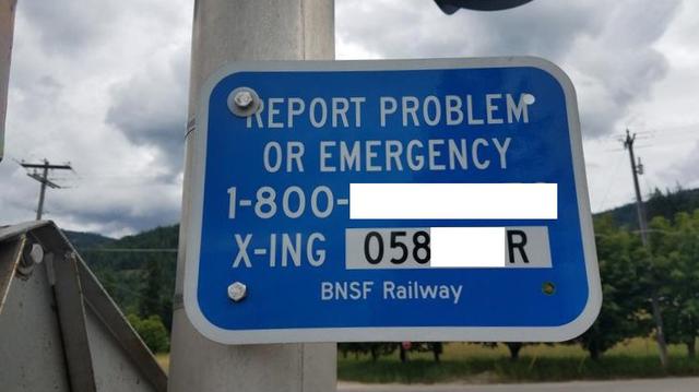
UPDATE 8/11/2020 - FOR EMERGENCY ISSUES FOR RAILROAD CROSSINGS - CALL THE RAILROAD COMPANY PHONE NUMBER ON THE BLUE SIGN POSTED TO THE RIGHT SIDE OF THE CROSSING. IT WILL HAVE THE CROSSING NUMBER POSTED ON THE SIGN. SEE EXAMPLE BELOW. THESE SIGNS ARE CROSSING SPECIFIC FOR PHONE NUMBER FOR EACH SPECIFIC RAILROAD.
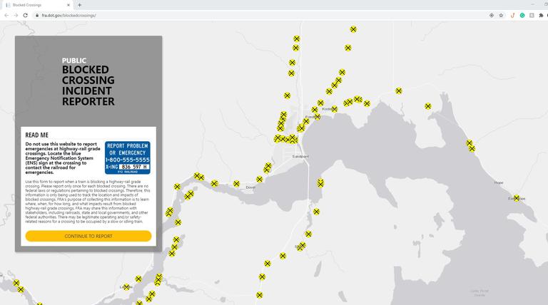
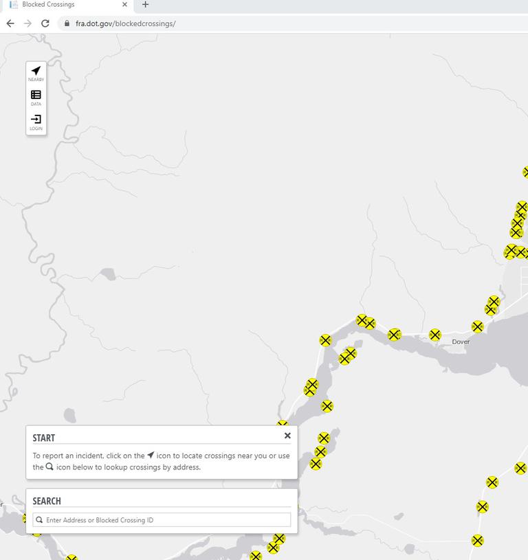
UPDATE 8/11/2020 BLOCKED RAILROAD CROSSINGS - NON EMERGENCY - WHERE TO REPORT THE DATA
Please click on the link below to report blocked railroad crossings (over 15 minutes).
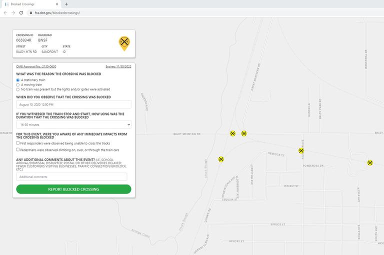
It's a simple form to complete. Identify the crossing number on the sign or click the crossing location on the map, click General Public Report, 1.) answer if the train was stationary, moving or no train, but lights or crossing gate was activated, 2.) the date, 3.) duration crossing was blocked, and 4.) any immediate impacts. Please share this with as many people as necessary so we can accurately capture blocked crossing data. The Federal Railroad Administration will use this reporting function to track crossings that are blocked regularly and this will give them more data to pursue enforcement against railroads that are repeat offenders.
Note: The information needs to be reported within 7 days of the blocked crossing incident.
https://www.fra.dot.gov/blockedcrossings/
UPDATE 7/23/2020- BEGINNING AT 8:30 AM, MONDAY, JULY 27TH KOOTENAI BAY ROAD WILL BE LIMITED TO ONE LANE TRAFFIC FOR INSTALLATION OF MEDIAN / BOLLARDS TO DIRECT TRAFFIC FOR THE QUIET ZONE "NO TRAIN WHISTLE" FOR THE PONDER POINT - WHISKEY JACK ACCESS. FLAGGERS WILL BE ON SITE. EXPECT DELAYS.
Contractor to install a median and bollards in the at-grade railroad crossing, one of the final steps in attaining the Kootenai Bay Road "Quiet Zone" designation from the Federal Railroad Administration. This will be similar to the one in East Hope.
Update 7/23/2020 - Our crews are busy rebuilding and resurfacing roads throughout the County this summer. Chipseal application continues in District 1 in the Blanchard area next week. Wooded Acres Drive is slated for BST application in mid to late August. Chip sealing equipment is shared by the three road districts and goes to District 2 following repairs. District 2 roads to be done include E and W Cedar Ln, Eastshore Rd, Freeman Lake Rd, Hoodoo Loop, Hoop Loop and LeClerc Rd. District 3 will follow with River Rd, Lightning Creek Rd, East Spring Creek Rd, River Lake and N River Lake Dr.
7/01/2020 Message from Steve Klatt, Director, Road and Bridge Department
Reflections – Summer 2020
The past three months have been a most interesting time in the life of the Bonner County Road Department. Mid-March found us shuffling half crews on and off for the next six weeks, during which our summer construction schedule began to slip immediately. By the time we got our full crews working together again, Mother Nature decided to play pranks upon us with frequent and persistent rain events. Now, at the end of June, we are finishing our mag chloride treatments of early June.
The interruptions and rain delays have also upended our construction schedules for this year. We have been able to get a substantial amount of work done on North Kootenai Road, brushing work done up on Eastshore Road at Priest Lake, and several smaller roads graveled near Cocolalla Lake that have been waiting a few years. A project impacted by this year’s interruptions has been our BST project for Lakeshore Drive being split into road improvements later this year and surface treatment being completed next summer.
Chip sealing projects will get underway right after the Fourth in the Sagle area, move out to the Clark Fork area and then up to Priest Lake. Depending on what little tricks Mother Nature is hiding up her sleeves, we should be done with chips around the middle of August. We will have a crew working on brushing and ditches up Baldy Mountain Road, plus a contractor clearing right-of-way on Woodland Drive. We are working on setting up a guardrail project for an area on Denton Road and the striping of roads will get under contract before too much longer.
Bonner County got a unique opportunity to participate in planning efforts funded by the Federal Highway Administration to create a Local Roads Safety Plan. The numbers of serious and fatal crashes on local roads is disconcerting at best and I have wanted to study our crash data to determine if similarities in crashes exist that might be treated systemically for improved driver safety. This effort has been made a bit cumbersome by COVID 19 restrictions on travel this year, but getting traffic safety planners to help us analyze our road system is a good starting point. We have been awarded a grant for right-of-way clearing of hazard trees in a couple of years and that will help reduce the severity of future crashes.
We are working on a project to replace a small bridge that is failing out on the Gypsy Bay Road after summer traffic slows down and have a bridge deck restoration job scheduled up on Peninsula Road once we begin to have some warm days. There are three more intersection lights we will have installed on Highway 95 south of Sandpoint later this summer and will continue to expand our lighted intersection program each year. Hard to believe, but we are beginning to gather up our stockpiles of anti-skid material for winter already in a program that costs nearly $2 million each season. It has been good to add three new trucks to our aging fleet.
Let’s all drive safely and have patience with our crews working to improve your county roads.
Steve Klatt, Director
UPDATE 6/15/2020 - N. KOOTENAI ROAD WILL BE CLOSED AT THE FOLLOWING LOCATIONS FOR CROSS CULVERT REPLACEMENT
MONDAY, JUNE 15TH 7AM TO 4PM - 1200 BLK
TUESDAY-WEDNESDAY JUNE 16TH 7AM THRU JUNE 17TH APPROX 3PM AT 2800 BLK
THURSDAY, JUNE 18TH7AM TO 4PM - 3200 BLK
UPDATE 6/09/2020 - BNSF WILL BE CLOSING THE SAGLE ROAD RAILROAD CROSSING FOR TRACK MAINTENANCE ON MONDAY, JUNE 15TH FROM 8:30 AM - 5 PM. PLEASE USE ALTERNATE ROUTES.
UPDATE 6/02/2020- BNSF WILL BE CLOSING THE ALGOMA SPUR RAILROAD CROSSING FRIDAY, JUNE 5TH FROM 8:30 AM - 4 PM FOR TRACK MAINTENANCE
UPDATE 5/27/2020 - CREW IS WORKING ON IMPROVING RIGHT OF WAY ON N KOOTENAI RD - ROCK HAMMER AT WORK
UPDATE 5/26/2020 MONTANA RAIL LINK RAILROAD CROSSING CLOSURES FOR TRACK MAINTENANCE
W Oden Bay Road Railroad crossing will be closed on Wednesday, May 27th from 8 am to 2 pm. No other outlet - Please plan accordingly
Kootenai Bay Road Railroad Crossing will be closed Monday, June 1st from 9 am to 2 pm. No other outlet - Please plan accordingly
UPDATE 5/18/2020 -WEIGHT LIMITS - All county roads have been lifted from weight limits.
UPDATE 4/17/2020 - UPCOMING BNSF RAILROAD CROSSING CLOSURES FOR TRACK MAINTENANCE
W Oden Bay Rd - Wednesday, 4/22/2020 9 am - 2 pm - No other outlet - Please plan accordingly
Bottle Bay Rd - Thursday, 4/23/20250 8 am - 5 pm
Barnhart Rd - Tuesday, 4/28/2020 8 am - 5 pm
UPDATE 4/03/2020 - BNSF WILL BE CLOSING THE BOTTLE BAY RAILROAD CROSSING OVERNIGHT ON WEDNESDAY, APRIL 8TH AT 7:30 AM THRU THURSDAY APRIL 9TH AROUND 4 PM.
UPDATE 3/25/2020 - BNSF IS CLOSING THE BARNHART ROAD RAILROAD CROSSING AT 8:30 AM TODAY, 3/25/2020 THRU 3 PM TOMORROW, 3/26/2020 FOR TRACK MAINTENANCE.
UPDATE 3/24/2020 - BARNHART ROAD RAILROAD CROSSING CLOSURE CHANGE BY BNSF RAILROAD
BNSF will need to close the crossing overnight on Thursday as opposed to opening them up that afternoon. The crossing will be closed from 8:30 am Thursday through 3 pm on Friday for track maintenance.
Please make the necessary arrangements.
UPDATE 3/20/2020 - BNSF WILL BE CLOSING THE FOLLOWING RAILROAD CROSSINGS FOR TRACK MAINTENANCE
Bottle Bay Rd - Monday, 3-23-2020 - 8:30 am - 5 pm
Sportsman Access Rd - Wednesday, 3-25-2020 - 8:30 am - 5 pm
Barnhart Rd - Thursday, 3-26-2020 - 8:30 am -5 pm
N Granite Loop - Friday, 3-27-2020 - 8 am - 5 pm
Sportsman Access Rd - Tuesday 3-31-2020 - 8:30 am - 5 pm
UPDATE 3/19/2020 - BNSF will be closing the Bottle Bay Road railroad crossing for track maintenance on Monday, March 23rd from 8:30 to 4 pm instead of Tuesday. As of now, they will not be closing it overnight.
UPDATE 3/16/2020 - BNSF WILL BE CLOSING THE FOLLOWING RAILROAD CROSSINGS FOR TRACK REPAIRS.
Huckleberry Mountain Road - Tuesday, March 17th, 9am to 5pm and Wednesday, March 18th, 9 am to 3pm.
Bottle Bay Rd - Tuesday, March 24th from 8am overnight, reopening at approximately 4pm.
Please plan accordingly.
UPDATE 2/03/2020 - WEIGHT LIMITS - EASTRIVER SLIDE 6400 BLOCK
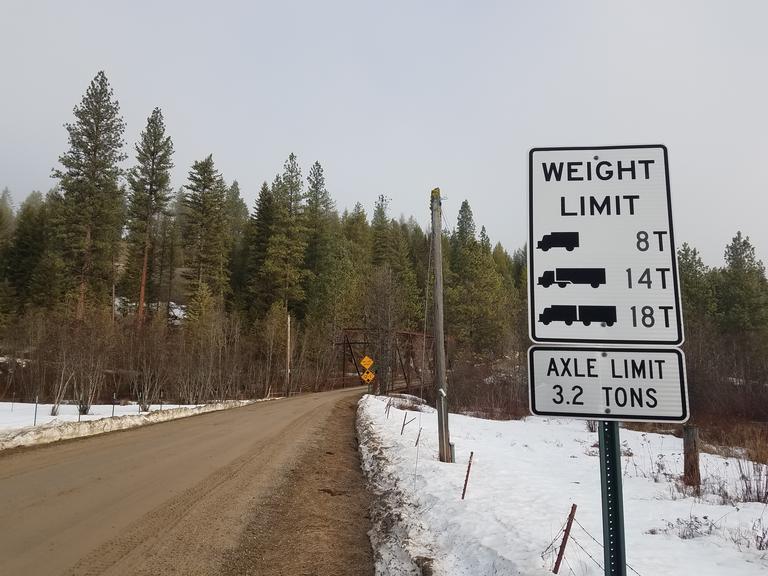
UPDATE 1/31/2020 - WEIGHT LIMITS
District 1 – South of the Long Bridge
All roads are posted are green flags. Weight limits may be posted on some roads next week.
District 2 – Priest River/Priest Lake
All roads will be posted with green flags today, January 31st. Weight limits may be posted on some roads next week.
District 3 – Sandpoint / Clark Fork
Johnson Creek Rd, E Spring Creek Rd and Mosquito Creek Rd are posted with weight limits.
Per BCRC Ordinance #422, it shall be the responsibility of the hauler to contact the Road & Bridge Department to determine whether or not these restrictions are in place.
These restrictions will remain in effect until changed, at which time updates will be posted.
Per BCRC Ordinance #422, it shall be the responsibility of the hauler to contact the Road & Bridge Department to determine whether or not these restrictions are in place.
For additional information, contact Bonner County Road & Bridge at 255.5681 ext 1 between the hours of 7 am to 4 pm. After hours please call 208.255.5681 #8 for weight limits.
11/27/2019 - Update - Winter driving conditions - County roads are not maintained 24 hours a day. To report County "maintained" road condition issues such as downed trees blocking the roads, icy roads, large snowdrifts, heavy snow accumulations, etc, call Road and Bridge, 208-255-5681, and press option #1, Monday - Friday 7 am - 4 pm. During holidays, weekends or after hours, please call Bonner County Dispatch at 208-265-5525 to make a report of serious issues... Dispatch has the ability to contact the foremen.
Drive safe and have a Happy Thanksgiving!
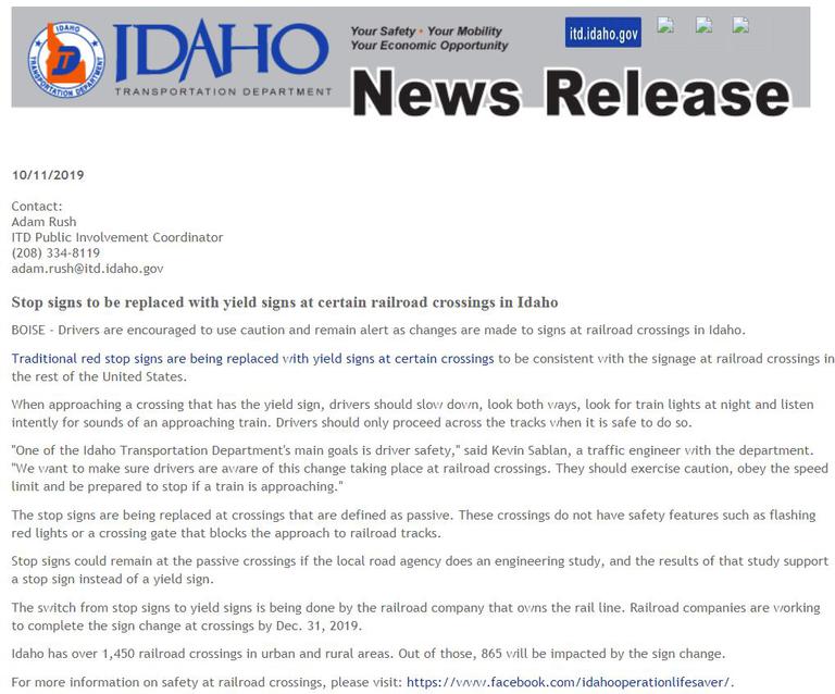
UPDATE 11/14/2019 -STOP SIGNS TO BE REPLACED WITH YIELD SIGNS AT CERTAIN RAILROAD CROSSINGS IN IDAHO
Residents may notice conflicting Stop Ahead, Stop and Yield signs at certain passive railroad crossings as the railroad companies are replacing signage within their right of way. The switch from stop signs to yield signs is being done by the railroad company that owns the rail line. Railroad companies are working to complete the sign change at crossings by Dec. 31, 2019. The Bonner County Road Department is removing the stop signs laying in the right of way along County maintained roads once the railroad contractors have installed the new Yield signs.
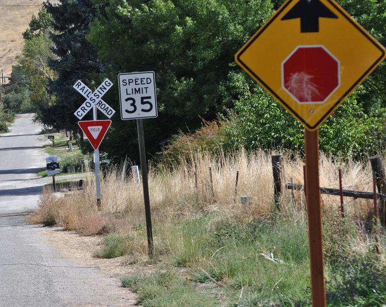
When approaching a crossing that has a yield sign, drivers should slow down, look both ways, look for train lights at night and listen intently for sounds of an approaching train and only proceed across the tracks when it's safe to do so. Drivers should exercise caution, obey the speed limit and be prepared to stop if a train is approaching.
UPDATE 11/12/2019 - FIRST WINTER SNOWSTORM - PLEASE DRIVE FOR THE CONDITIONS
WINTER MAINTENANCE MESSAGE FROM DIRECTOR KLATT
Hello Bonner County Drivers – As the clouds begin to gather after a remarkably beautiful October, we are confronted with our annual conundrum, “Are we going to be ready for winter driving on our local rural roads?” Winter road maintenance is expensive, hazardous for operators and time-consuming. Bonner County spent nearly $2,000,000 last winter providing safer roads. Please remember to make sure you have winter tires on your rig and that County roads are not maintained 24 hours a day. Hopefully, this winter is not as early and persistent as last winter was.
Mailboxes in county road rights-of-way suffer greatly from snow plowing activity and are the responsibility of the owner. Most people underestimate the weight of snow being pushed from the road, so if you can wiggle your mailbox, there is a fair probability that plowed snow will take it down. County operators do not intentionally damage mailboxes but, maintain speed to throw snow from the road. The growing number of garbage cans placed for pickup within the right of way must be kept out of the plowed travel surface because they will end up in the ditch and create an unsightly mess that individuals are responsible for.
Snowplowing commences after several inches have accumulated on roadways. Bonner County Road & Bridge operates three districts to maintain 680+ miles of road, but all adhere to these priorities for our winter maintenance:
1st Priority School bus routes, arterials, and major collectors
2nd Priority All other county maintained roads after 1st Priority roadways
3rd Priority Sanding generally begins after plowing a road is completed. Sand is applied to steeper roadway grades, at intersections, on bridges, and other areas determined to be hazardous. It is not standard policy to sand straight stretches of the roadway because of snow. Road salt is not used.
Residents who remove snow from their driveways are reminded that Idaho Code 18-3906 prohibits placing snow or ice on any public road in a manner that impedes traffic or makes it unsafe and 18-3907 prohibits the placing of snow in any manner that affects the water flow of a ditch line. If your snow plowing affects the County’s plowing or anyone driving the road, you are breaking the law.
YOU CAN HELP
There are several ways the public can help make the County’s job more cost-effective and safe:
- Vehicles must not be parked on roadways during snow events. Vehicles will be buried in the snow berm and/or towed if interfering with the plow route. Once bermed in, it is the resident’s responsibility to shovel their vehicle out. Please remember – our roads are not city streets!
- Landscape features such as rocks, fences or planters should be removed from the rights-of-way for the winter. They may be destroyed by snow plowing, but they also can do substantial damage to snowplows. Owners are responsible for County equipment unnecessarily damaged.
- Do not push snow over ends of culverts or drainage structures. Rapid warming cycles in winter could result in overloaded ditches being unable to drain. Local flooding could occur.
- Mailboxes are damaged during snow removal operations. Replacement of damaged mailboxes is the responsibility of the property owner/resident per the Bonner County Road Standards Manual, Section 8.
- Snow removal operations require the use of large and heavy equipment during periods of darkness usually accompanied by limited visibility caused by falling snow. Bonner County operators are trained and safety is stressed at all times. Drivers of automobiles should follow at a safe distance where the operator can see you in his mirrors.
- Children love to watch the large equipment, noise, lights, and activity of snow removal operations. Please keep children a safe distance away. The concentration required for snow removal means the operators may not always be able to see people close by and accidents could result.
- Please encourage children NOT to build tunnels, forts or play in snow berms.
UPDATE 11/07/2019 DUFORT ROAD INTERSECTION WIDENING PROJECT HAS BEEN COMPLETED.


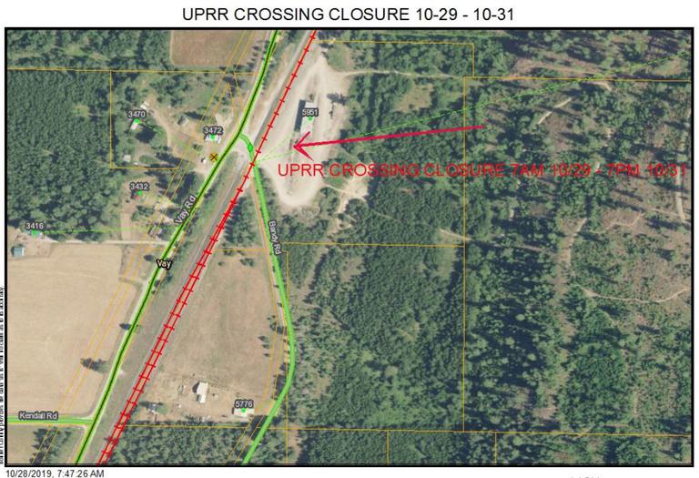
UPDATE 10/28/2019 - UNION PACIFIC RAILROAD WILL BE CLOSING THE ROAD RAILROAD CROSSING AT THE NORTH END OF BANDY ROAD FROM TUESDAY, OCTOBER 29TH AT 7 AM UNTIL THURSDAY, OCTOBER 31ST AT 7 PM FOR REPAIRS.
UPDATE 10/25/2019 - DUFORT ROAD INTERSECTION WIDENING PROJECT CONTINUES. PAVING IS PROJECTED TO TAKE PLACE NEXT THURSDAY, 10/31/2019.


UPDATE 10/24/2019 - HIGHWAY 95 - DUFORT ROAD INTERSECTION TURN LANE ADDITION - WORK IS UNDERWAY ON THE TURN LANE ADDITION TO DUFORT ROAD AT HIGHWAY 95 INTERSECTION WITH MOST OF THE WORK SLATED TO BE COMPLETED IN THE NEXT WEEK OR TWO.
BEFORE

CURRENTLY WORK IS UNDERWAY

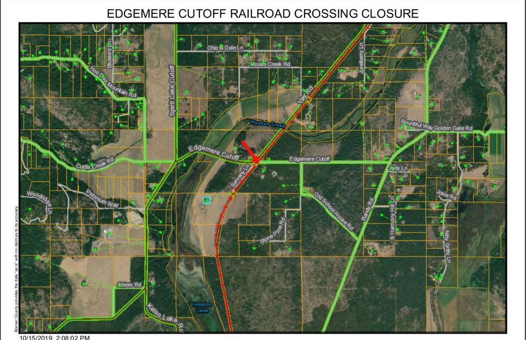
UPDATE 10/15/2019 - UNION PACIFIC RAILROAD WILL BE CLOSING EDGEMERE CUTOFF RAILROAD CROSSING FOR REPAIRS FROM THURSDAY, OCTOBER 17TH AT 7 AM THROUGH FRIDAY, OCTOBER 18TH UNTIL 5 PM. SEE MAP LINK BELOW
EDGEMERE CTF RR CROSSING CLOSURE (1).pdf
UPDATE 10/10/2019 - DICKENSHEET ROAD - NEW GUARDRAIL INSTALLATION COMPLETED
UPDATE 10/09/2019 - BNSF RAILROAD WILL BE CLOSING HOMESTEAD ROAD RAILROAD CROSSING ON MONDAY, OCT 14TH FROM 10 AM - 3 PM FOR PAVING. PLEASE PLAN ACCORDINGLY.
UPDATE 10/08/2019 - EMERGENCY REPAIRS UNION PACIFIC RAILROAD CROSSING CLOSURES EXTENDED
DUE TO MUCH MORE EXTENSIVE WORK ON THE TRACKS, KELSO - CLAGSTONE CUTOFF RAILROAD CROSSING WILL BE CLOSED UNTIL APPROXIMATELY 5 PM TODAY.
KELSO LAKE ROAD RAILROAD CROSSING WILL BE CLOSED TUESDAY, OCT 15TH THROUGH THURSDAY, OCT 17TH. PLEASE PLAN ACCORDINGLY.
UPDATE 10/07/2019 - EMERGENCY RAILROAD CROSSING REPAIRS BY UNION PACIFIC RAILROAD
Kelso Clagstone Cutoff Rd at the tracks - Sat, Oct 5th from 3pm thru Mon, Oct 7th 4pm
8300 Blk of Kelso Lake Rd at the tracks - Mon, Oct 7th from 4pm thru Tue, Oct 8th 5pm
UPDATE 10/07/2019 - BALDY MOUNTAIN ROAD CLOSURE TUESDAY, OCT. 8TH FROM 9 AM - 11 AM FOR A CROSS CULVERT REPLACEMENT NEAR ( LARSEN RANCH ROAD INTERSECTION). PLEASE PLAN ACCORDINGLY.
UPDATE 9/10/2019 - TWO ROAD WORK PROJECTS IN DISTRICT 1 THIS WEEK.
BAYVIEW ROAD WILL BE CHIPSEALED TOMORROW, 9/11/2019. PILOT CARS WILL BE USED, EXPECT DELAYS FROM 7 AM - 4:30 PM
WOODED ACRES DR WILL RECEIVE THE 2ND APPLICATION OF BST THURSDAY, 9/12/2019. PILOT CARS WILL BE USED, EXPECT DELAYS FROM 8 AM - 4:30 PM
UPDATE 9/06/2019 TWO UPCOMING ROAD PROJECTS IN DISTRICT 3 NEXT WEEK - ELMIRA ROAD AT HIGHWAY 95 AND EAST SPRING CREEK
Monday 9/9/2019 one crew will be working on the intersection of Highway 95 and west Elmira. There will be flaggers and maybe short delays. Another crew will be putting rock in the shoulders of the new pavement on East Spring Creek. We should have both projects finished by the afternoon of 9/10/2019.
UPDATE 9/05/2019 UPCOMING BNSF RAILROAD CROSSING CLOSURE AT HOMESTEAD RD WEDNESDAY SEPTEMBER 11TH.
BNSF will be closing Homestead Rd at the RR tracks on Wednesday, Sept 11th from 8:30 am to 5 pm for repairs.
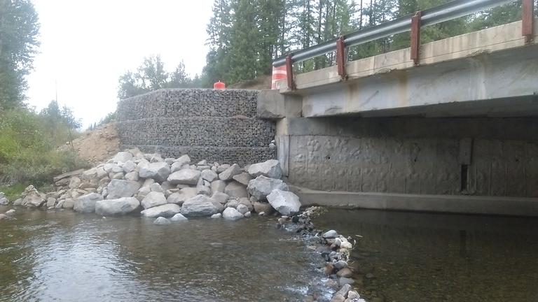
UPDATE 8/30/2019 GROUSE CREEK BRIDGE REPAIRS
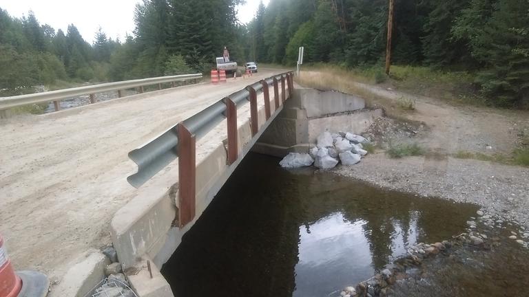
Gabion wall, erosion and scour protection, concrete repairs, and new guard rails coming. Pumping some new life into this old bridge. The new guard rails will extend past the end of the bridge, wrap back and be secured deeper into the beams. The current guard rails were only secured to the outside and are broken loose as shown in the bottom photo.
UPDATE 8/19/2019 - UPCOMING BNSF RAILROAD CROSSING CLOSURE AT NORTH END OF GRANITE LOOP
BNSF will be closing the NORTH end of Granite Loop at the railroad tracks starting Wed, Aug 21st at 8 am and reopening Thursday, Aug 22nd at approx 5 pm.
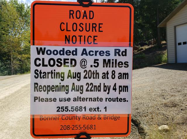
UPDATE 8/14/2019 - WOODED ACRES ROAD WILL BE CLOSED FOR MAINTENANCE FROM TUESDAY, AUGUST 20 THROUGH THURSDAY AUGUST 22. THE DETOUR VIA WESTWOOD HEIGHTS RD, LOWER MUSKRAT SPUR, MUSKRAT LAKE RD, GYPSY BAY RD TO LAKESHORE DRIVE WILL BE OPEN.
SEE DETOUR MAP BELOW: WOODED ACRES ROAD CLOSURE - DETOUR MAP.pdf
UPDATE 8/08/2019 - GROUSE CREEK BRIDGE REHABILITATION PROJECT BEGINS MONDAY, AUGUST 12TH.

Expect delays as this project will be ongoing for a while. See map below:
UPDATE 8/08/2019 - CHIPSEALING PROJECTS IN DISTRICT 3 BEGIN NEXT WEEK
Upcoming chip seal projects in District 3 beginning Monday, August 12, 2019 are as follows:
1) Upper Pack River Rd 7.1 Miles
2) Elmira Rd .4 Miles
3) Samuels Rd 3.67 Miles
4) Grouse Creek Cutoff 1.2 Miles
5) Jacobson Rd 1.52 Miles
6) Lower Pack River Rd 3.03 Miles
Pilot cars will be leading traffic through, expect delays.
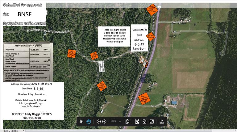
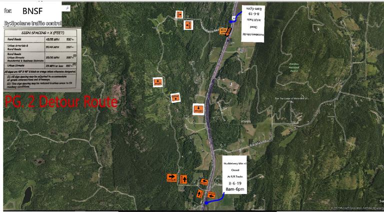
UPDATE 7/31/2019 - BNSF WILL BE CLOSING THE HUCKLEBERRY MOUNTAIN ROAD RAILROAD CROSSING FOR REPAIRS ON 8/06/2019 FROM 8 AM - 6 PM.
SEE DETOUR MAP LINKS BELOW.
TCP- Huckleberry mtn rd (BNSF) 8-6-19.pdf
TCP- Huckleberry mtn rd detour (BNSF) 8-6-19.pdf
UPDATE 7/24/2019 - BNSF HAS RESCHEDULED THE RAILROAD CROSSING CLOSURE AT THE SOUTH END OF GRANITE LOOP, AGAIN, TO THURSDAY, AUGUST 1ST AT 8 AM AND REOPENING THE FOLLOWING DAY, FRIDAY, AUGUST 2ND AT 5 PM.
UPDATE 7/22/2019 - UPCOMING BNSF CROSSING CLOSURE MONDAY JULY 29TH - 30TH
BNSF WILL BE CLOSING THE RAILROAD CROSSING AT THE SOUTH END OF GRANITE LOOP STARTING MONDAY, JULY 29TH AT 8 AM AND REOPENING THE FOLLOWING DAY, TUESDAY, JULY 30TH. AT 5 PM. SEE DETOUR MAP LINK BELOW:
TCP- S end of Granite Loop 7-29-7-30(BNSF) Closure.pdf
UPDATE 7/02/2019 - UPCOMING SUMMER - FALL ROAD PROJECTS
District 1 Sagle Area - July - August - Wooded Acres Drive - Prep work, ditching and BST treatment, expect delays until late August when the road will be closed for a week. Detour will be out Westwood Heights, Lower Muskrat Spur, Muskrat Lake Rd, Gypsy Bay Rd to Lakeshore Dr during the road closure.
Jewel Lake Rd (west end) brushing and ditch work in right of way during August. Expect delays
Sagle Rd brushing and ditch work during the month of September. Expect delays.
5/30/2019 - GRANITE LOOP RAILROAD CROSSING CLOSURE, SOUTH END UPDATE - BNSF ran into some mechanic issues today on the repair of the railroad tracks, therefore the railroad crossing at the south end of Granite Loop will be closed overnight until midday tomorrow. They apologize for the inconvenience.
UPDATE 5/28/2019 - BNSF WILL BE CLOSING THE RAILROAD CROSSING AT THE SOUTH END OF GRANITE LOOP THURSDAY, MAY 30TH FROM 8:30 AM TO 5:00 PM FOR REPAIRS. DETOUR SIGNS WILL BE POSTED.
UPDATE 5/15/2019 - WEIGHT LIMITS HAVE BEEN LIFTED ON ALL ROADS
UPDATE 5/14/2019 - WEIGHT LIMIT CHANGE - ONLY TRESTLE CREEK ROAD IS STILL ON WEIGHT RESTRICTION.
District 1 – South of the Long Bridge
All roads have been lifted from weight limits.
District 2 – Priest River/Priest Lake
All roads have been lifted from weight limits.
District 3 – Sandpoint / Clark Fork
All roads have been lifted from weight limits except for; Trestle Creek Rd
UPDATE 5/13/2019 - WEIGHT LIMITS CHANGE
District 1 – South of the Long Bridge
All roads have been lifted from weight limits except for; Eichs Rd and Martin Bay Rd.
District 2 – Priest River/Priest Lake
All roads have been lifted from weight limits.
District 3 – Sandpoint / Clark Fork
All roads have been lifted from weight limits except for; Trestle Creek Rd
UPDATE 5/09/2019 - WEIGHT LIMITS CHANGES
District 1 – South of the Long Bridge
All roads have been lifted from weight limits except for; Eichs Rd, Sunset Rd and Martin Bay Rd.
District 2 – Priest River/Priest Lake
All roads have been lifted from weight limits. FYI- The detour for Eastriver Rd, starting at the 5770 block is Eastriver Loop in which the bridge has an axle limit of 3.2 tons.
District 3 – Sandpoint / Clark Fork
All roads have been lifted from weight limits except for; Trestle Creek Rd
UPDATE 5/07/2019 - WEIGHT LIMITS CHANGES IN DISTRICT 2 - EASTSHORE ROAD IS OPEN TO HAULING AS OF TODAY.
District 1 – South of the Long Bridge
All roads have been lifted from weight limits except for; Merrill Martin Rd both ends, Eichs Rd, Jewel Lake Rd, Sunset Rd and Martin Bay Rd.
District 2 – Priest River/Priest Lake
All roads have been lifted from weight limits. FYI- The detour for Eastriver Rd, starting at the 5770 block is Eastriver Loop in which the bridge has an axle limit of 3.2 tons.
District 3 – Sandpoint / Clark Fork
All roads have been lifted from weight limits except for; Upper Gold Creek Rd, Rapid Lightning from mm 7600 (where it meets Upper Gold), Trestle Creek Rd and W. Spring Creek.
UPDATE 5/06/2019 - WEIGHT LIMITS CHANGES IN DISTRICT 1 - MORE ROADS OPEN TO HAULING
District 1 – South of the Long Bridge
All roads have been lifted from weight limits except for; Merrill Martin Rd both ends, Eichs Rd, Jewel Lake Rd, Sunset Rd and Martin Bay Rd.
District 2 – Priest River/Priest Lake
All roads have been lifted from weight limits except for; Eastshore Rd from mm 8.5 (at Indian Creek Campground) to Canoe Point Rd, mm 17.5. The detour for Eastriver Rd, starting at the 5770 block is Eastriver Loop in which the bridge has an axle limit of 3.2 tons.
District 3 – Sandpoint / Clark Fork
All roads have been lifted from weight limits except for; Upper Gold Creek Rd, Rapid Lightning from mm 7600 (where it meets Upper Gold), Trestle Creek Rd and W. Spring Creek.
UPDATE 5/03/2019 - WEIGHT LIMITS CHANGE - RIVER ROAD IN CLARK FORK HAS BEEN REMOVED FROM WEIGHT LIMITS RESTRICTIONS
District 1 – South of the Long Bridge
All roads have been lifted from weight limits except for; Pend Oreille Dr, Merrill Martin Rd both ends, Wooded Acres, Cocolalla Loop, Algoma Spur, Heath Lake Rd, Old Highway 95, Overlake View Rd, Blacktail Rd, Butler Creek Spur, Sunset Rd, Southside School Rd, Sherwoods Rd, Martin Bay Rd and Comeback Bay Rd and Jewel Lake Rd which are closed to all hauling.
District 2 – Priest River/Priest Lake
All roads have been lifted from weight limits except for; Eastshore Rd from mm 8.5 (at Indian Creek Campground) to Canoe Point Rd, mm 17.5. The detour for Eastriver Rd, starting at the 5770 block is Eastriver Loop in which the bridge has an axle limit of 3.2 tons.
District 3 – Sandpoint / Clark Fork
All roads have been lifted from weight limits except for; Upper Gold Creek Rd, Rapid Lightning from mm 7600 (where it meets Upper Gold) , Trestle Creek Rd and W. Spring Creek.
UPDATE 5/03/2019 - COCOLALLA LOOP BNSF CROSSING WILL BE OPEN TODAY, BUT CLOSED WEDNESDAY, MAY 8TH FOR REPAIRS
BNSF will be closing the railroad crossing at the north end of Cocolalla Loop on Wednesday, May 8th from 7:30 am to 4 pm for railroad crossing repairs. Use south end of Cocolalla Loop detour.
UPDATE 5/02/2019 - COCOLALLA LOOP, NORTH END BNSF RAILROAD CROSSING CLOSED FOR REPAIRS
BNSF has closed the railroad crossing on the north end of Cocolalla Loop for today, tomorrow ( May 3rd) and Wed, May 8th from 7:30 am to 4 pm for railroad crossing repairs. Use south end of Cocolalla Loop detour.
UPDATE 5/01/2019 - WEIGHT LIMITS CHANGES
District 1 – South of the Long Bridge
All roads have been lifted from weight limits except for; Pend Oreille Dr, Merrill Martin Rd both ends, Wooded Acres, Cocolalla Loop, Algoma Spur, Heath Lake Rd, Old Highway 95, Overlake View Rd, Blacktail Rd, Butler Creek Spur, Sunset Rd, Southside School Rd, Sherwoods Rd, and Martin Bay Rd. Comeback Bay Rd and Jewel Lake Rd are closed to all hauling.
District 2 – Priest River/Priest Lake
All roads have been lifted from weight limits except for; Eastshore Rd from mm 8.5 (at Indian Creek Campground) to Canoe Point Rd, mm 17.5. The detour for Eastriver Rd, starting at the 5770 block is Eastriver Loop in which the bridge has an axle limit of 3.2 tons.
District 3 – Sandpoint / Clark Fork
All roads have been lifted from weight limits except for; Upper Gold Creek Rd, Rapid Lightning from mm 7600 (where it meets Upper Gold) , Trestle Creek Rd, W. Spring Creek and River Rd from Twin Creek eastbound
UPDATE 4/30/2019 - WEIGHT LIMITS CHANGES
The following roads are still posted with weight limits; Pend Oreille Dr, Merrill Martin Rd both ends, Wooded Acres, Cocolalla Loop, Algoma Spur, Heath Lake Rd, Old Highway 95, Martin Bay Rd, Overlake View Rd, Blacktail Rd, Butler Creek Spur, Sunset Rd, Southside School Rd, Sherwoods Rd. Comeback Bay Rd and Jewel Lake Rd are both still closed to all hauling.
District 2 – Priest River/Priest Lake
All roads have been lifted from weight limits except for; Eastshore Rd from mm 8.5 (at Indian Creek Campground) to Canoe Point Rd, mm 17.5. The detour for Eastriver Rd, starting at the 5770 block is Eastriver Loop in which the bridge has an axle limit of 3.2 tons.
District 3 – Sandpoint / Clark Fork
The following roads are still posted with weight limits. Upper Pack River Rd from Caribou Crk Rd north, Upper Gold Creek Rd, Rapid Lightning from mm 1.587 (store), Trestle Creek Rd, W. Spring Creek, River Rd from Twin Creek eastbound. Woodland Dr and Sunnyside Rd from mile marker 7864 to Hwy 200 which is the eastern portion of Sunnyside Rd or backside are still closed to all hauling.
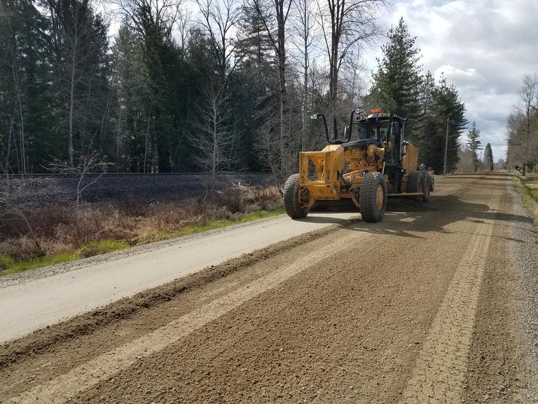
UPDATE 4/23/2019 ROAD GRADERS ARE OUT IN FULL FORCE TODAY
GRADING NORTH BOYER ROAD
UPDATE 4/15/2019 - WEIGHT LIMITS - EASTSHORE ROAD CLOSED TO HAULING FROM INDIAN CREEK TO CANOE POINT - DISTRICT 2
TRAFFIC LIMITED TO RESIDENTIAL TRAFFIC, EMERGENCY VEHICLES AND ESSENTIAL HAULERS WITH PERMITS ISSUED FOR HALF LOADS BY ROAD AND BRIDGE DEPARTMENT
District 1 – South of the Long Bridge
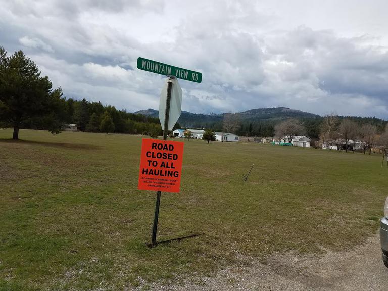
All roads are posted with weight limits. The following roads are closed to All Hauling, therefore limited to residential vehicles and essential haulers only; Birch Banks Rd, Hanford Dr, E Comeback Bay Rd, Comeback Bay Rd, Algoma Spur, Jewel Lake Rd, Cocolalla Loop and Mountain View Rd in Blanchard.
District 2 – Priest River/Priest Lake
All roads are posted with weight limits. Eastshore Rd from mm 8.5 (at Indian Creek Campground) to Canoe Point Rd, mm 17.5 is closed to All Hauling.
District 3 – Sandpoint / Clark Fork
All roads are posted with weight limits. The following roads are closed to All Hauling, therefore limited to residential vehicles and essential haulers only; Woodland Dr and Sunnyside Rd from mile marker 7864 to Hwy 200 which is the eastern portion of Sunnyside Rd or backside.
UPDATE 4/10/2019 - WEIGHT LIMITS - ANOTHER ROAD CLOSED TO HAULING IN DISTRICT 1 - MOUNTAIN VIEW RD - BLANCHARD
TRAFFIC LIMITED TO RESIDENTIAL TRAFFIC, EMERGENCY VEHICLES AND ESSENTIAL HAULERS WITH PERMITS ISSUED FOR HALF LOADS BY ROAD AND BRIDGE DEPARTMENT
District 1 – South of the Long Bridge
All roads are posted with weight limits. The following roads are closed to All Hauling, therefore limited to residential vehicles and essential haulers only; Birch Banks Rd, Hanford Dr, E Comeback Bay Rd, Comeback Bay Rd, Algoma Spur, Jewel Lake Rd, Cocolalla Loop and Mountain View Rd in Blanchard.
District 2 – Priest River/Priest Lake
All roads are posted with weight limits.
District 3 – Sandpoint / Clark Fork
All roads are posted with weight limits. The following roads are closed to All Hauling, therefore limited to residential vehicles and essential haulers only; Woodland Dr and Sunnyside Rd from mile marker 7864 to Hwy 200 which is the eastern portion of Sunnyside Rd or backside.
Per BCRC Ordinance #422, it shall be the responsibility of the hauler to contact the Road & Bridge Department to determine whether or not these restrictions are in place.
These restrictions will remain in effect until changed, at which time updates will be posted.
For additional information, contact Bonner County Road & Bridge at 255.5681ext 1 between the hours of 7am to 4pm.
After hours please call 208.255.5681 #8 for weight limits.
UPDATE 4/08/2019 - WEIGHT LIMITS - MORE ROADS CLOSED TO HAULING IN DISTRICT 3 - NORTH AND EAST OF SANDPOINT
District 1 – South of the Long Bridge
All roads are posted with weight limits. The following roads are closed to All Hauling, therefore limited to residential vehicles and essential haulers only; Birch Banks Rd, Hanford Dr, E Comeback Bay Rd, Comeback Bay Rd, Algoma Spur, Jewel Lake Rd and Cocolalla Loop.
District 2 – Priest River/Priest Lake
All roads are posted with weight limits.
District 3 – Sandpoint / Clark Fork
All roads are posted with weight limits. The following roads are closed to All Hauling, therefore limited to residential vehicles and essential haulers only; Woodland Dr and Sunnyside Rd from mile marker 7864 to Hwy 200 which is the eastern portion of Sunnyside Rd or backside.
NO EARLY MORNING HAULING WILL BE ALLOWED ON ANY BONNER COUNTY MAINTAINED ROAD POSTED WITH WEIGHT LIMITS!
UPDATE 4/04/2019 - WEIGHT LIMITS - SEVERAL ROADS CLOSED TO HAULING IN SAGLE AND COCOLALLA AREA
District 1 – South of the Long Bridge
All roads are posted with weight limits. The following roads are CLOSED TO ALL HAULING, therefore limited to residential vehicles and essential haulers only; Birch Banks Rd, Hanford Dr, E Comback Bay Rd, Comback Bay Rd, Algoma Spur, Jewel Lake Rd and Cocololla Loop.
UPDATE 4/03/2019 - HOMESTEAD RD RAILROAD CROSSING CLOSURE BY BNSF HAS BEEN RESCHEDULED FOR MONDAY, APRIL 8TH. PLEASE PLAN ACCORDINGLY
UPDATE 3/27/2019 - UPCOMING BNSF RAILROAD CROSSING MAINTENANCE CLOSURES
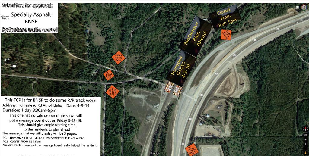
Homestead Road on 4-03-19 from 8:30 am -5 pm - No safe detour route, so public will need to plan ahead.
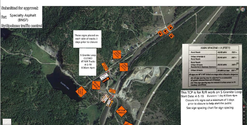
S Granite Loop on 4-05-19 from 8:30 am- 4 pm - Detour will be out the north end of Granite Loop.
MARCH 27, 2019 REMINDER - EASTRIVER LOOP BRIDGE RESTRICTIONS
THE BRIDGE BELOW IS ON EASTRIVER LOOP (THE DETOUR FOR THE EASTRIVER ROAD SLIDE CLOSURE)
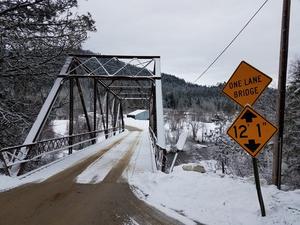
The Eastriver Loop bridge has load restrictions of 3.2 ton per axle and a height restriction of 12' 1".
No oversized loads. Weight limits are in effect.
MARCH 25, 2019 - Effective Immediately! Eastriver Rd is closed at the 6400 block due to a slide.
Please use Eastriver Loop detour. Local traffic only.
The Eastriver Loop bridge has load restrictions of 3.2 ton per axle and a height restriction of 12' 1".
No oversized loads. Weight limits are in effect.
Signs are posted at the south and north ends of Eastriver Loop.
EASTRIVER SLIDE DETOUR - EASTRIVER LOOP.pdf
MARCH 22, 2019 - ALL BONNER COUNTY ROADS ARE POSTED WITH WEIGHT LIMITS UNTIL FURTHER NOTICE.
March 19, 2019 - WEIGHT LIMITS
NO EARLY MORNING HAULING WILL BE ALLOWED ON ANY BONNER COUNTY MAINTAINED ROAD POSTED WITH WEIGHT LIMITS!
District 1 – South of the Long Bridge - All roads are posted with weight limits.
District 2 – Priest River/Priest Lake - All roads south of Dickensheet Rd (including Dickensheet Rd) are posted with weight limits,
District 3 – Sandpoint / Clark Fork - All roads are posted with weight limits.
Per BCRC Ordinance #422, it shall be the responsibility of the hauler to contact the Road & Bridge Department to determine whether or not these restrictions are in place. These restrictions will remain in effect until changed, at which time updates will be posted.
For additional information, contact Bonner County Road & Bridge at 255.5681 ext 1 between the hours of 7 am to 4 pm. After hours please call 208.255.5681 #8 for weight limits.
March 14, 2019 - WEIGHT LIMITS
NO EARLY MORNING HAULING WILL BE ALLOWED ON ANY BONNER COUNTY MAINTAINED ROAD POSTED WITH WEIGHT LIMITS!
District 1 – South of the Long Bridge - All roads will be posted with green flags on Friday, March 15th indicating weight limits are imminent.
District 2 – Priest River/Priest Lake - All roads will be posted with green flags on Friday, March 15th indicating weight limits are imminent.
District 3 – Sandpoint / Clark Fork - Grouse Creek Rd and Grouse Creek Cutoff are posted with red flags, therefore weight limits are effective immediately. All other roads will be posted with green flags by Friday, March 15th indicated weight limits are imminent.
Per BCRC Ordinance #422, it shall be the responsibility of the hauler to contact the Road & Bridge Department to determine whether or not these restrictions are in place. These restrictions will remain in effect until changed, at which time updates will be posted.
For additional information, contact Bonner County Road & Bridge at 255.5681 ext 1 between the hours of 7 am to 4 pm. After hours please call 208.255.5681 #8 for weight limits.
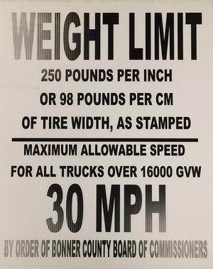
UPDATE 3/13/2019 - All county roads will be posted with green flags by Friday, March 15th indicating weight limits are imminent.
UPDATE 3/05/2019 - DRIFTING AND BLOWING SNOW CONTINUES- PLEASE DRIVE FOR THE CONDITIONS
COLBURN CULVER RD
SELLE RD
| Check out our new Railroad Crossing Information page . |  |
Bonner County equipment operators have a multitude of things going on to plow snow. Please use caution around snow plowing equipment in operation.
Inside the cab of a county snow plow truck. Lots of levers and shifting going on and he's currently not even applying sand because it is still actively snowing. Note that the plow truck driver is too busy to wave and interact with the public while he's operating snow removal equipment.
UPDATE 2/26/2019
Crews are working to clear drifts from yesterday's high wind and blowing snow. Drive with caution as many roads are icy, especially in shaded areas.
Selle Rd
UPDATE 2/07/2019
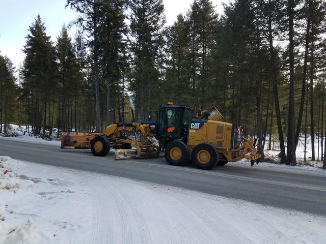
Scraping ice down on Old Priest River Rd 2/07/2019.
UPDATE 2/01/2019
Crews are out pushing back berms and scraping icy snow floors down. Please drive with caution.
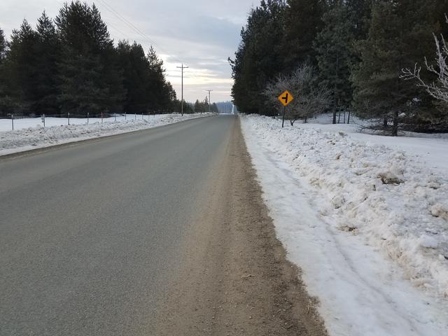
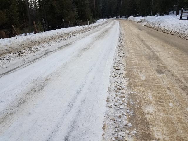
Preventive Measures in Winter Road Maintenance
People sometimes wonder why Road & Bridge will send graders out this time of year to clear road edges, cut snow berms down and push the snow back from the roads. These efforts are preparations for forecasted heavy rain events and the fact that February is historically the month of greatest snowfall. Extra efforts are made to cut holes in snow berms to create drainage points so water does not collect on the roadway.
The Road Department has full use of our entire right of way for maintenance measures and in areas of multiple driveways, graders often push snow in larger piles deep in the right of way that people sometimes think of as part of their yards. Pushing these piles off the road edge actually helps improve the sight distance for those private driveways and promotes greater safety for everyone on the road.
Road & Bridge has several key missions in our operations – promote traveler safety and protect the integrity of our roads. Giving water a pathway off our roads enhances safety and helps protect our roads shoulders from erosion.
Let’s all try to be patient dealing with winter road maintenance, we have turned the corner of this winter toward better weather. In the meantime, our crews are working hard to keep road conditions as safe as possible.
UPDATE 1/25/2019
Icy Conditions and Plowing/Sanding
Our policy is to not sand while it is still actively snowing. After snowfall stops we sand where needed after plowing. If you call after hours, voice mail will be received the following business day. (If you have an emergency situation after hours that needs to be addressed, please call 911 or dispatch at 208-265-5525 to report the issue with the Bonner County Sheriff’s Department.)Dispatch will notify the proper district foreman if a call out is necessary.
With a little sunshine and warmer weather, snow floors are breaking up. Crews will be out for a bit this weekend to clean up some of the roads and the rest will be addressed on Monday. Snow melts slowly causing water to run between the ruts and as soon as temperatures drop that water becomes ice. The crews have sanded, but the shaded areas are very dangerous. Please slow down and be careful.
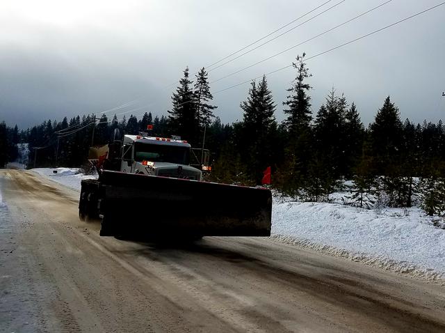
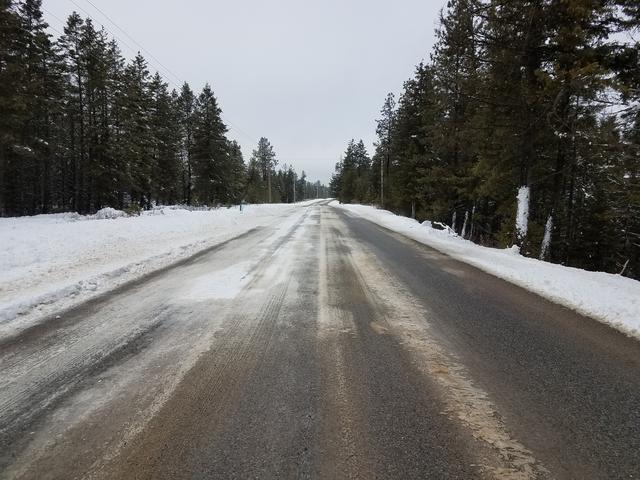
Sanding truck operators turn off the sanders when they see traffic approaching, but the rotor continues to turn and the moving truck causes sand to continue for a bit. Safely pull over when you are meeting a sanding plow truck to avoid damage to your vehicle.
UPDATE 11/08/2018
BNSF Railroad has just informed us that next week's pending closure at the RR track crossing at 10000 block of Baldy Mtn Rd will now be extended to four days, from Tuesday, Nov 13th at 8 am THROUGH Friday, Nov 16th until approx. 6 pm. The repair work is more extensive than they originally anticipated. If BNSF cannot complete the paving Friday, then they will fill with gravel for the weekend until it can be completed.
UPDATE 11/07/2018
BNSF will be closing the Rail Road Crossings at the 10,000 block of Baldy Mountain Rd (just past Great Northern Rd) starting Tuesday, Nov 13th at 8 am through Wednesday Nov 14th at 5 pm for major repairs. Detour signs will be set up three days prior. UPDATE FOR BALDY MOUNTAIN ROAD CLOSURE
WINTER MAINTENANCE MESSAGE FROM DIRECTOR KLATT
Hello Bonner County Drivers – As the clouds begin to gather after a remarkably beautiful October, we are confronted with our annual conundrum, “Are we going to be ready for winter driving on our local rural roads?” Winter road maintenance is expensive, hazardous for operators and time consuming. Bonner County spent nearly $2,000,000 last winter providing safer roads. Please remember to make sure you have winter tires on your rig and that County roads are not maintained 24 hours a day. Hopefully, this winter is not as early and persistent as last winter was.
Mailboxes in county road rights-of-way suffer greatly from snow plowing activity and are the responsibility of the owner. Most people underestimate the weight of snow being pushed from the road, so if you can wiggle your mailbox, there is a fair probability that plowed snow will take it down. County operators do not intentionally damage mailboxes, but maintain speed to throw snow from the road. The growing number of garbage cans placed for pickup within the right of way must be kept out of the plowed travel surface because they will end up in the ditch and create an unsightly mess that individuals are responsible for.
Snow plowing commences after several inches have accumulated on roadways. Bonner County Road & Bridge operates three districts to maintain 680+ miles of road, but all adhere to these priorities for our winter maintenance:
1st Priority School bus routes, arterials and major collectors
2nd Priority All other county maintained roads after 1st Priority roadways
3rd Priority Sanding generally begins after plowing a road is completed. Sand is applied to steeper roadway grades, at intersections, on bridges, and other areas determined to be hazardous. It is not standard policy to sand straight stretches of roadway because of snow. Road salt is not used.
Residents who remove snow from their driveways are reminded that Idaho Code 18-3906 prohibits placing snow or ice on any public road in a manner that impedes traffic or makes it unsafe and 18-3907 prohibits the placing of snow in any manner that affects the water flow of a ditch line. If your snow plowing affects the County’s plowing or anyone driving the road, you are breaking the law.
YOU CAN HELP
There are several ways the public can help make the County’s job more cost effective and safe:
- Vehicles must not be parked on roadways during snow events. Vehicles will be buried in the snow berm and/or towed if interfering with the plow route. Once bermed in, it is the resident’s responsibility to shovel their vehicle out. Please remember – our roads are not city streets!
- Landscape features such as rocks, fences or planters should be removed from the rights-of-way for the winter. They may be destroyed by snow plowing, but they also can do substantial damage to snow plows. Owners are responsible for County equipment unnecessarily damaged.
- Do not push snow over ends of culverts or drainage structures. Rapid warming cycles in winter could result in overloaded ditches being unable to drain. Local flooding could occur.
- Mailboxes are damaged during snow removal operations. Replacement of damaged mailboxes is the responsibility of the property owner/resident per the Bonner County Road Standards Manual, Section 8.
- Snow removal operations require the use of large and heavy equipment during periods of darkness usually accompanied by limited visibility caused by falling snow. Bonner County operators are trained and safety is stressed at all times. Drivers of automobiles should follow at a safe distance where the operator can see you in his mirrors.
- Children love to watch the large equipment, noise, lights and activity of snow removal operations. Please keep children a safe distance away. The concentration required for snow removal, means the operators may not always be able to see people close by and accidents could result.
- Please encourage children NOT to build tunnels, forts or play in snow berms.
Printable pdf below
Winter Maintenance Press Release 2018-19.pdf
UPDATE 11/01/2018 - SUNNYSIDE ROAD WILL REOPEN TODAY BY 5 PM. THE ASPHALT PATCH WILL BE COMPLETED NEXT WEEK, WEATHER PERMITTING.
UPDATE 10/31/2018 - SUNNYSIDE RD - DAVIS SLOUGH CROSS-CULVERT INSTALLATION PROGRESS
This project is progressing nicely. The culvert is installed and compaction of fill is underway. Weather permitting, Sunnyside Road should be reopened Friday by 4 pm.
UPDATE 10/25/2018 - FRIDAY, OCTOBER 26TH - BALDY MOUNTAIN ROAD CLOSURE FOR CULVERT INSTALLATION.
BALDY MOUNTAIN ROAD WILL BE CLOSED 7 MILES WEST OF THE BNSF RAILROAD TRACKS FRIDAY, OCTOBER 26TH, 8 AM - 4 PM WHILE A CROSS CULVERT IS BEING INSTALLED. THIS WORK IN THE PUBLIC SECTION OF BALDY RD IS BEING DONE BY A CONTRACTOR.
UPDATE 10/22/2018 - UPCOMING BNSF RAILROAD CROSSING CLOSURES
S end of Cocoalla Loop - Wednesday, Oct 24th from 9-4
Homestead Rd - Thursday, Oct 25th from 9-4
UPDATE 10/11/2018 - UPCOMING CLOSURE OF SUNNYSIDE RD AT MILE MARKER 1.7
FROM 8AM MONDAY, OCTOBER 29TH THRU FRIDAY NOVEMBER 2ND AT 4PM. ROAD CREWS WILL BE INSTALLING A HUGE CROSS CULVERT AT DAVIS SLOUGH. DETOUR WILL BE VIA THE EAST END OF SUNNYSIDE RD. (CREWS IMPROVED THE EAST END ROAD THIS PAST SUMMER.)
UPDATE 10/05/2018 - BNSF is rescheduling the Heath Lake RR closure from today to Monday, Oct 8th 9am to 4pm.
UPDATE 10/04/2018 - POLITICAL SIGNS ARE NOT ALLOWED IN COUNTY ROAD RIGHT OF WAY
BEGINNING NEXT WEEK BONNER COUNTY ROAD CREWS WILL REMOVE ANY POLITICAL SIGNS FOUND IN COUNTY ROAD RIGHT OF WAY.
UPDATE 9/28/2018 - UPCOMING BNSF RAILROAD CROSSING CLOSURES
Bottle Bay Rd RR crossing, Thursday, 10/04/2018 from 9-4
E Dufort Rd RR crossing, Friday, 10/05/2018 from 9-4
Health Lake Rd RR crossing, Friday, 10/05/2018 from 9-4
UPDATE 9/25/2018 - UPCOMING CLOSURE - COLBURN-CULVER RD TUESDAY, OCT 2, 7:45 AM - 4 PM
Colburn-Culver Rd just west of N Center Valley will be completely closed for a cross culvert installation on Tuesday, October 2nd from 7:45 am to approximately 4pm. A detour route will be posted.
UPDATE 9/21/2018 - BOTTLE BAY INTERSECTION AT HIGHWAY 95 IS NOW OPEN
Bonner County Road & Bridge Director, Steve Klatt congratulates Randy McDougall of Earthworks Northwest on their substantial completion of the Bottle Bay Rd/ Highway 95 Intersection Safety Project. The intersection has been reopened.
Official Bonner County Highway Map - 2018
Click Link to view Official Bonner County Highway Map below.
UPDATE 9/14/2018
BONNER COUNTY TRANSPORTATION PLAN OPEN HOUSE - WEDNESDAY, SEPTEMBER 19TH 4 - 6 PM, HELD IN THE 1ST FLOOR CONFERENCE ROOM OF BONNER COUNTY ADMIN BUILDING LOCATED AT 1500 HIGHWAY 2 IN SANDPOINT. Feel free to stop in anytime between 4 pm and 6 pm to view draft exhibits regarding the County's short and long term transportation priorities and provide feedback to the team developing the plan.
UPDATE 9/07/2018 - BAYVIEW RD REBUILD PROJECT
Today, the contractor is working on Bayview Rd driveway transitions so property owners have quality access until the next phase of the road project is completed. Paving will begin Tuesday, September 18th and continue through September 23rd.
UPDATE 9/05/2018 BOTTLE BAY HIGHWAY 95 INTERSECTION PROJECT
Bike path tunnel assembled and back fill is still underway. The project adds a designated turn lane and widens the intersection in addition to moving the bike path. It was slated to be completed October 1st, but is expected to be finished later this month. The contractor is making good progress rebuilding the roadway. Paving, painting lanes and installation of guard rails will need to be completed prior to reopening the intersection.
VIEW FROM NORTH SIDE
VIEW OF GRAVITY WALL PRECAST BLOCK FROM SOUTH SIDE
PRECAST GRAVITY WALL BLOCK IS INSTALLED TO SUPPORT ROAD BED ON EACH SIDE
VIEW FROM JONES ROAD 9/05/2018
VIEW OF INTERSECTION FROM WEST SIDE OF HIGHWAY 95 8/29/2018
VIEW FROM NORTH SIDE 8/29/2018
UPDATE 9/05/2018 - SAGLE ROAD DITCHING AND BRUSHING - EXPECT 15 MIN DELAYS
BEGINNING 9/04/2018, ROAD CREWS WILL BE BRUSHING, DITCHING AND CLEANING THE RIGHT OF WAY ALONG SAGLE ROAD IN THE 2000 BLOCK NEAR GOLD MTN DR WORKING THEIR WAY EAST THROUGH EARLY OCTOBER. MONDAY - THURSDAY FROM 8 AM - 4 PM COMMUTERS CAN EXPECT 15 MINUTE DELAYS WITH PILOT CARS TAKING TRAFFIC THROUGH THE ACTIVE WORK AREA.
UPDATE 8/24/2018 BOTTLE BAY HIGHWAY 95 INTERSECTION PROJECT
Bike path tunnel assembled and back fill is underway. The project will add a designated turn lane and widen the intersection in addition to moving the bike path. It was slated to be completed October 1st, but is expected to be finished in mid to late September.
Views from North and South entrances of bike tunnel.
This project is funded by Local Highway Safety Improvement Program grant from LHTAC Local Hwy Technical Assistance
The intersection was identified as highest priority as part of 2016 Bottle Bay Rd Safety Audit with 12 accidents and 1 fatality.
UPDATE 8/16/2018 ROAD WORK
MONDAY SHOULD MARK COMPLETION OF REBUILDING THE BACKSIDE OF SUNNYSIDE ROAD IN PREPARATION FOR THE DETOUR DURING THE 1700 BLOCK CLOSURE FOR THE DAVIS SLOUGH CULVERT REPLACEMENT LATER THIS FALL.
EVERGREEN ROAD WILL BE CLOSED IN THE 1200 BLOCK FOR CULVERT REPLACEMENT OF THE SAND CREEK CROSS CULVERT UNDER THE ROADWAY FOR 3 DAYS, AUGUST 27TH THROUGH AUGUST 30TH
UPCOMING ROAD CLOSURE - EASTSIDE RD - OVERNIGHT CLOSURE
Eastside Rd in Priest River at MM 8.3 will be completely closed from 7am on Tuesday, August 14th through 4 pm on Wednesday, August 15th for the Blue Creek culvert replacement. Please use alternate routes.
UPCOMING BNSF RAILROAD CROSSING CLOSURES
E Dufort Rd Wednesday, 8-8-18 from 7:30 am-6 pm 1 day
Heath Lake Rd Wednesday 8-8-18 at 7:30 am overnight until 3 pm on Thursday, 8-9-18
South end of Cocallala Loop Friday, 8-10-18 from 7 am-5:30 pm 1 day
Update 8/06/2018 Bottle Bay Rd-Hwy 95 Intersection Project
Contractor begins assembling bike path tunnel. The intersection project is slated to be completed October 1st.
BURLINGTON NORTHERN SANTA FE RAILROAD
The number to call if a train is blocking the Bottle Bay Rd railroad crossing #058828R in excess of 20 minutes is 800-832-5452 BNSF DISPATCH
6/25/2018 UPDATE - SAGLE AREA BNSF RAILROAD CROSSING OVERNIGHT CLOSURES THIS WEEK
5/21/2018 EASTRIVER ROAD REOPENS TODAY
THE SLIDE REPAIR HAS BEEN COMPLETED AT THE 6400 BLOCK OF EASTRIVER RD.
UPDATE 5/16/2018 - PROJECT DELAY
BOTTLE BAY - HIGHWAY 95 INTERSECTION PROJECT START DATE DELAYED TO JUNE 25TH WITH COMPLETION SCHEDULED TO BE OCTOBER 1ST.
CRITICAL MATERIAL ISSUES CAUSE DELAY OF START DATE FOR BOTTLE BAY RD - HIGHWAY 95 INTERSECTION PROJECT
Bottle Bay Rd Intersection with Highway 95 will be closed for intersection reconstruction. The safety grant project will create left and right turn lanes onto the highway and an underpass for the bike path. The intersection will be closed for the duration of this project. The 3.1 mile long detour to Highway 95 will be via Lignite Road to Sagle Road. See Map Link Below.
BOTTLE BAY PROJECT DETOUR1 MAP.pdf
5/14/2018 WEIGHT LIMITS UPDATE
ALL ROADS HAVE BEEN LIFTED FROM WEIGHT LIMITS EXCEPT FOR EICHS ROAD IN DISTRICT ONE - SOUTH OF THE LONG BRIDGE AND TRESTLE CREEK RD AT MILE MARKER 2.3 EASTBOUND IN DISTRICT 3 - SANDPOINT / CLARK FORK.
UPDATE 5/08/2018 - PROJECT DELAY
PERMIT ISSUES CAUSE 1 WEEK DELAY OF START DATE FOR BOTTLE BAY RD - HIGHWAY 95 INTERSECTION PROJECT
WEIGHT LIMITS UPDATE 5/07/2018
District 1 – South of the Long Bridge
All roads have been lifted from limits EXCEPT FOR; The north end of Blacktail Rd from Highway 95 to Little Blacktail, Pinewood Ln, Eichs Rd, E. Comeback Bay Rd, Comeback Bay Rd, Otts Basin Rd and Sunset Rd.
District 2 – Priest River/Priest Lake
All roads have been lifted from weight limits.
District 3 – Sandpoint / Clark Fork
All roads have been lifted from weight limits EXCEPT FOR; Trestle Creek Rd at MM 2.3 going eastbound.
*
UPDATE - 5/03/2018 - NOTICE
RAILROAD CROSSING CLOSURE
BY BNSF RAILROAD AT SAGLE RD,
FRIDAY, MAY 11TH, 7:30 AM -7:00 PM
BNSF will be closing the Sagle Rd railroad crossing Friday, May 11th from 7:30 am - 7 pm. Detour routes will be signed and are shown below.
Paving of this railroad crossing will be completed on Thursday, May 24th, with flagging to keep traffic flowing as smoothly as possible.
CLOSURE INFORMATION
DETOUR ROUTES
UPDATE - 4/27/2018 - NOTICE
PENDING BOTTLE BAY ROAD CLOSURE AT HIGHWAY 95 INTERSECTION -
MAY 14 THROUGH AUGUST 15, 2018
DETOUR VIA LIGNITE RD TO SAGLE RD
May 14 - August 15, 2018, Bottle Bay Rd Intersection with Highway 95 will be closed for intersection reconstruction. The safety grant project will create left and right turn lanes onto the highway and an underpass for the bike path. The intersection will be closed for the duration of this project. The 3.1 mile long detour to Highway 95 will be via Lignite Road to Sagle Road. See Map Below.
EASTRIVER RD SLIDE - 6400 BLOCK
EASTRIVER RD SLIDE (note orange cones are 42" tall)
Eastriver Rd is closed at the 6400 block due to a slide. Please use the Eastriver Loop detour. Local traffic only.
The Eastriver Loop bridge has load restrictions of 3.2 ton per axle and a height restriction of 12' 1".
No oversized loads. Weight limits are in effect.
Signs are posted at the south and north ends of Eastriver Loop. This is effective immediately.
MARCH 9, 2018 - WEIGHT LIMITS UPDATE
Weight limits are in effect for all county roads.
* Early morning hauling is no longer allowed.*
March 8, 2018 Update - Crews are pushing back snow berms.
This is an example of “winging”. The wing blade is mounted to the side of the grader and is used to knock the berm down so the next snow event there is space for the plows to dump their snow. Please be aware that this excess snow will impact driveways and is the property owner’s responsibility to clear .
MARCH 5, 2018 - WEIGHT LIMITS UPDATE
District 1 – South of the Long Bridge
All roads will be posted with weight limits starting Wednesday, March 7 th . However, early morning hauling from 2am to 9am will be allowed from Wednesday, March 7 th through Friday, March 9 th . After 9am on Friday, weight limits will be in full effect 24 hours a day.
District 2 – Priest River/Priest Lake
All roads will be posted with weight limits starting Wednesday, March 7 th . However, early morning hauling from 2am to 9am will be allowed from Wednesday, March 7 th through Friday, March 9 th . After 9am on Friday, weight limits will be in full effect 24 hours a day.
District 3 – Sandpoint / Clark Fork
All roads will be posted with weight limits starting Wednesday, March 7 th . However, early morning hauling from 2am to 9am will be allowed from Wednesday, March 7 th through Friday, March 9 th . After 9am on Friday, weight limits will be in full effect 24 hours a day.
MARCH 1, 2018 - WEIGHT LIMITS UPDATE
District 1 – South of the Long Bridge
All roads will continue to be lifted from weight limits through Tuesday, March 6 th .
District 2 – Priest River/Priest Lake
All roads will continue to be lifted from weight limits through Tuesday, March 6 th .
District 3 – Sandpoint / Clark Fork
All roads will continue to be lifted from weight limits through Tuesday, March 6 th .
Per BCRC Ordinance #422, it shall be the responsibility of the hauler to contact the Road & Bridge Department to determine whether or not these restrictions are in place.
These restrictions will remain in effect until changed, at which time updates will be posted.
UPDATE FEBRUARY 13, 2018
STARTING TUESDAY MORNING, FEBRUARY 13 TH , EARLY MORNING HAULING WILL BE ALLOWED ON ALL COUNTY ROADS FROM 2AM TO 9AM ONLY. THIS WILL BE ALSO BE IN EFFECT WEDNESDAY AND THURSDAY, FEBRUARY 14 TH AND 15 TH RESPECTIVELY.
AN UPDATE WILL BE SENT OUT ON THURSDAY AFTERNOON FOR THE WEEKEND.
EASTRIVER ROAD CLOSED INDEFINITELY FEBRUARY 9, 2018 DUE TO SLIDE IN 6400 BLOCK.
2/09/2018 - Effective Immediately!
Eastriver Rd is closed at the 6400 block due to a slide. Please use Eastriver Loop detour. Local traffic only.
The Eastriver Loop bridge has load restrictions of 3.2 ton per axle and a height restriction of 12' 1".
No oversized loads. Weight limits are in effect.
Signs are posted at the south and north ends of Eastriver Loop.
6400 Block Eastriver Rd 2/08/2018 above and 2/07/2018 below
Update: February 8, 2018 Weight Limits -
Just a reminder that even though the temps may be below freezing for a couple of days, no early morning hauling will be allowed on any Bonner County maintained road posted with weight limits.
Update: February 5, 2018 Weight Limits
District 1 – South of the Long Bridge
All roads are posted with weight limits.
District 2 – Priest River/Priest Lake
All roads from Dickensheet south (including Dickensheet) are posted with weight limits. All other roads are posted with green flags, therefore weight limits are imminent.
District 3 – Sandpoint / Clark Fork
All roads are posted with weight limits EXCEPT for Upper Pack River Rd.
DETOUR Eastriver Loop Bridge Restrictions 3.2 ton per axle and 12'1" clearance - No oversize loads
Weight Limits are in effect.
NO EARLY MORNING HAULING WILL BE ALLOWED ON ANY BONNER COUNTY MAINTAINED ROAD POSTED WITH WEIGHT LIMITS!
Warmer temps are impacting roads causing settling and heaving. Please drive with care.
1700 Block Lakeshore Dr.
New Sportsman Access Road intersection located at 145 Cocolalla Loop is now open
New box culvert at former Sportsman Access Road location
Former Sportsman Access Road located off Highway 95 is now named Peters Court
Sportsman Access Road flooded by over 3' of water March 15, 2017, and was closed to traffic

(click snowflake for complete winter road maintenance guide)
Bonner County Road & Bridge offers the following information to assist new and long-time residents who have questions and concerns of how the Road & Bridge Department prioritizes its snowplowing during the winter months. We also offer information on how residents can be proactive in securing their mailboxes and safeguarding articles that are placed in the County Right-of-Way. We want everyone to have a safe and secure winter.
WINTER ROAD MAINTENANCE GUIDE
Bonner County Road & Bridge maintains 709 miles of roads within the County operating from three Districts. Sub-priorities have been set up as guidelines to aid District Foreman in making decisions, as follows:
1st Priority - School bus routes, arterials, and major collectors.
2nd Priority - All other county maintained roads after 1 st Priority roadways.
Snow removal operations will generally begin after a sufficient accumulation of snow. Snow is plowed from roadways to provide two-way traffic as soon as practicable.

The County maintenance shops screen and stockpile sand for each road district to apply in winter for traction.
3rd Priority - Sanding will not be performed until the roadway has been plowed. Use of sand is limited to steep roadway grades such as in mountainous terrain, at intersections, on overhead structures, and in other areas determined by the department to be hazardous. It is not standard policy to sand straight stretches of roadway because of snow. Road salt is not used. Sand is not applied between 11pm – 4am due to no midnight crewman.

Ice bits have been installed on many of the County graders to apply grooves to the packed snow floor and ice for traction sand to collect.
10/24/2017
BNSF will be closing the Sagle Rd RR crossing near Lignite Rd on Monday, October 30th from 9am to 5pm . Please use alternate routes.”
Update 9/27/2017
The east end of Denton Road (from the intersection with Highway 200) will be closed Friday, September 29 from 1pm – 1 am Saturday, September 30, 2017, for filming by Radioflash Film, LLC. The detour will be to Old Sam Owen Dr.
Update 9/22/2017
Sportsman Access Road entrance off Highway 95 in Cocolalla is being relocated. Burlington Northern Railroad is building a new access off the north end of Cocolalla Loop just west of the railroad tracks. The new road will be paved and open in just a few weeks.

New Sportsman Access Rd location off the north end of Cocolalla Loop – under construction
New Sportsman Access Rd currently under construction by BNSF railroad.

Sportsman Access Rd entrance off Highway 95 will be closed in the next few weeks. A new entrance is being constructed by BNSF railroad at the north end of Cocolalla Loop
Update 9/14/2017
A portion of Old Highway Rd off of Highway 200 will be closed on Tuesday, Sept. 19th starting at 8 am and will reopen on Wednesday afternoon Sept, 20th for a large culvert replacement. The work will be done at MM 496 (approx. 1/2 mile in) therefore both west and east ends will be open. Please plan your travels accordingly.
Update 7/11/2017 – Bottle Bay Rd

The contractor will continue paving Bottle Bay Road through the beginning of next week. Once the road surface is completed, they will be filling in the shoulders and driveway approaches in coming weeks.
BOTTLE BAY ROAD RESURFACING PROJECT ROAD CLOSURE & DETOUR
Bottle Bay Rd from Highway 95 to Hanford Dr will be closed on Wednesday , June 21st from 7 am to approximately 6 pm for a layer of cement to be mixed into the road base.
Residents on Jones Rd and Buck Run are to use Harbor View to exit. All other residents must use Lignite Rd. Also Bottle Bay Rd will be posted as a “no hauling” road for a period of one week for the cement base to cure. No heavy trucks or equipment will be allowed to use this portion of the road.
NO HAULING NOTICE!
EFFECTIVE MONDAY, JUNE 19 TH , 2017 AT 6AM, A CEMENT TREATED BASE WILL BE CONSTRUCTED ON TWEEDIE RD THEREFORE IT WILL BE POSTED AS A NO HAULING ROAD FOR 1 WEEK FOR THE CEMENT TO CURE. NO HEAVY TRUCKS OR EQUIPMENT WILL BE ALLOWED.
EFFECTIVE WEDNESDAY, JUNE 21ST, 2017 AT 6AM, A CEMENT TREATED BASE WILL BE CONSTRUCTED ON BOTTLE BAY RD FROM HIGHWAY 95 TO LIGNITE RD THEREFORE THIS PORTION OF BOTTLE BAY WILL BE CLOSED ALL DAY. DETOUR SIGNS WILL BE POSTED. IT WILL ALSO BE POSTED AS A NO HAULING ROAD FOR 1 WEEK FOR THE CEMENT TO CURE. NO HEAVY TRUCKS OR EQUIPMENT WILL BE ALLOWED.
WEIGHT LIMITS
PLEASE REMEMBER RED FLAG OR NO FLAG ON THE SIGN MEANS WEIGHT LIMITS ARE IN EFFECT!
These restrictions will remain in effect until changed, at which time updates will be posted.
For additional information, contact Bonner County Road & Bridge at 255.5681 ext 1 between the hours of 7am to 4pm. Monday through Friday
5/11/2017 Update – Road Projects
Lakeshore Dr. culvert replacement May 15th
The BC Road Crew will be replacing a culvert at the 5000 blk of Lakeshore Dr on Monday, May 15th from 8 to 3, please expect delays up to 45 minutes.
Bottle Bay resurfacing project begins May 16th
Road construction will start on Bottle Bay Rd on Tuesday, May 16th for approximately 4 weeks. Please expect delays.
4/01/2017
6400 Block Eastriver Rd Slide Area 3/31/2017

3/22/2017 Spring has sprung.
Graders are out as weather permits on roads that are stable enough for grading of the surface.

Grading of Talache Rd 3/22/2017
3/31/2017
Effective immediately, Martin Bay Rd in Sagle is closed to all hauling. This includes companies with permits as well. Please call Road & Bridge if an emergency comes up for residents needing heating fuel.
Martin Bay Rd is CLOSED TO ALL HAULING

Eastriver Slide Area 3/22/2017

3/17/2017 Effective Immediately!
Eastriver Rd is closed at the 6400 block due to a slide. Please use Eastriver Loop as the detour. Local traffic only. Signs are posted at the south and north ends of Eastriver Loop. This is effective immediately.
Click link below for detour route –
Detour Map
6400 block of Eastriver Rd – potential for slide 3/16/2017 – ROAD CLOSED – DETOUR VIA EASTRIVER SPUR
3/16/2017 Update – Thaw and Flooding
Bonner County Board of Commissioners has declared a State of Emergency in Bonner County due to flooding and damage.
To report significant road damage or safety issues due to the flooding conditions 7 am – 4 pm, please call the office at 255-5681 . After 4 pm, please call Bonner County Dispatch at 265-5525.

Gun Club Rd at Highway 95 on 3/16/2017

Sportsman Access Rd is flooded and closed. Residents are using an alternate access – Faith Ln off Cocolalla Loop.

Sportsman Access Rd is closed 3/15/2017 due to flooding
All Bonner County roads are now compromised to some extent due to the prolonged winter and on-going rain. Except for emergency repairs, there isn’t a lot Road & Bridge can do at this time. We recognize that potholes are appearing and growing at an exponential rate on most gravel roads. Frost still exists below most road surfaces evidenced by the moisture retained in and on the roads. If we start cutting out those potholes now and attempting to regrade the roads, road surfaces will quickly turn to a soupy mud bog-like mess. We hope the absence of rain over the next few days will prompt melting of the frost and drying of the road surfaces. As soon as that occurs, all our graders will be out restoring gravel roads to good condition. Our crews are out doing all they can to keep roads passable and safe.
WEIGHT LIMITS 3/10/2017
NO EARLY MORNING HAULING WILL BE ALLOWED ON ANY BONNER COUNTY MAINTAINED ROADS POSTED WITH WEIGHT LIMITS!
PLEASE REMEMBER RED FLAG OR NO FLAG ON THE SIGN MEANS WEIGHT LIMITS ARE IN EFFECT!
District 1 – South of the Long Bridge
All roads are posted with weight limits.
District 2 – Priest River/Priest Lake
All roads are posted with weight limits.
District 3 – Sandpoint / Clark Fork
All roads are posted with weight limits.
Per BCRC Ordinance #422, it shall be the responsibility of the hauler to contact the Road & Bridge Department to determine whether or not these restrictions are in place.
These restrictions will remain in effect until changed, at which time updates will be posted.
For additional information, contact Bonner County Road & Bridge at 255.5681 ext 1 between the hours of 7 am to 4 pm. Monday through Friday.

Curtis Creek Road – Sagle 3/02/2017
UPDATE 2/23/2017
WEIGHT LIMITS
Effective immediately: many roads have been posted with weight limits due to thawing and extreme saturation. See below:

4800 block Jewel Lake Rd – “One Lane Road”

Thawing and flooding is occurring on several County roads. Please be advised to proceed carefully and report any issues to the Road and Bridge Department, or if after business hours call Bonner County Dispatch at 265-5525.

300 block Whittum Rd. – Water is up to 4 1/2″ deep across road in this 100 foot section.
NO EARLY MORNING HAULING WILL BE ALLOWED ON ANY BONNER COUNTY MAINTAINED ROAD POSTED WITH WEIGHT LIMITS!
2/14/2017
PLEASE DRIVE FOR THE CONDITIONS!

With sunshine and warmer weather, snow melts slowly causing water to run between the ruts and as soon as temperatures drop that water becomes ice. The crews have sanded, but the shaded areas are very dangerous. Please slow down and be careful.

Sanding truck operators turn off the sanders when they see traffic approaching, but the rotor continues to turn and the moving truck causes sand to continue for a bit. Safely pull over when you are meeting a sanding plow truck to avoid damage to your vehicle.
2/10/2017
Please be advised: Dependent upon the thawing trends, Weight Limits may be considered for County roads in the next couple weeks.
Icy Conditions and Plowing/Sanding
Our policy is to not sand while it is still actively snowing. After snowfall stops we sand where needed after plowing. If you call after hours, voice mail will be received the following business day. ( If you have an emergency situation after hours that needs to be addressed, please call 911 or dispatch at 265-5525 to report the issue with the Bonner County Sheriff’s Department.) Dispatch will notify the proper district foreman if a call out is necessary.
1/24/2017

This is an example of “winging”. The wing blade is mounted to the side of the grader and is used to knock the berm down so the next snow event there is space for the plows to dump their snow. Please be aware that this excess snow will impact driveways and is the property owner’s responsibility to clear.
WINTER ROAD MAINTENANCE GUIDE
Bonner County Road & Bridge maintains 709 miles of roads within the County operating from three Districts.
Bonner County Road & Bridge offers the following information to assist new and long time residents who have questions and concerns of how the Road & Bridge Department prioritizes its snowplowing during the winter months.
Sub-priorities have been set up as guidelines to aid District Foreman in making decisions, as follows:
1 st Priority School bus routes, arterials and major collectors
2 nd Priority All other county maintained roads after 1 st Priority roadways
Snow removal operations will generally begin after a sufficient accumulation of snow. Snow is plowed from roadways to provide two-way traffic as soon as practicable.
The County maintenance shops screen and stockpile sand for each road district to apply in winter for traction.
3 rd Priority Sanding will not be performed until the roadway has been plowed. Use of sand is limited to steep roadway grades such as in mountainous terrain, at intersections, on overhead structures, and in other areas determined by the department to be hazardous. It is not standard policy to sand straight stretches of roadway because of snow.
Road salt is not used.
Sand is not applied between 11pm – 4am due to no midnight crewman.
Ice bits have been installed on many of the County graders to apply grooves to the packed snow floor and ice for traction sand to collect.
We also offer information on how residents can be proactive in securing their mailboxes and safeguarding articles that are placed in the County Right-of-Way. We want everyone to have a safe and secure winter.
Update 12/09/2016 Cavanaugh Bay Road opened to one lane traffic 12/08/2016.


Cavanaugh Bay Road opened to one lane traffic 12/08/2017. Crews continue to improve the road, so please drive with extreme caution.
12/06/2016 Back fill, fabric and rock are being put down.
Update 11/29/2016 Crews will be building retaining walls, pouring concrete and compacting fill to secure the culvert in place before any road material will be added to rebuild the road. There will still be ongoing site work to ready the project for winter. Paving is planned in the spring of 2017. (More pictures of the project progress can be viewed on our Road Projects page )
Soldier Creek Project Progress 12/01/2016
Back fill must be evenly completed and compacted on both sides to secure culvert in place.
11/30/2016 Backfill and retaining wall block with geogrid continues. Soldier Creek is flowing through the new 25′ diameter culvert. Forms are being set for concrete pour to hold culvert in place.
Update 11/21/2016 Culvert is assembled 11/21/2016 Cavanaugh Bay Road – Soldier Creek Culvert Replacement Project Due to record rainfall this month, the contractor has pushed the finish date for the Soldier Creek Crossing on Cavanaugh Bay Road to November 30th. See link to map of detour route below.
Crews assemble the 25′ diameter culvert at Soldier Creek.
11/15/2016 Assembly of the 25 diameter culvert begins.
11/14/2016 Crews finally have a dry and stable rock base in the bottom of the excavation.
Workers continue preparation of the base for the new 25′ diameter culvert 11/09/2016.
11/07/2016 Stream diversion measures and pumping finally work along with less rainfall to allow work on the Soldier Creek culvert replacement project to progress.
UPDATE 10/25/2016 Due to record rainfall this month, the contractor has pushed the finish date for the Soldier Creek Crossing on Cavanaugh Bay Road to November 17th. See link to map of detour route below. Record breaking heavy rainfall the month of October has caused project delays.
Stream flow and level 10/21/2016
UPDATE 9/29/2016 The contractor has pushed the start date of this project to October 10th with the finish date to remain November 3rd. Please be advised of the upcoming road closure – Cavanaugh Bay Rd at Soldier Creek crossing for culvert replacement. Signs are posted at both ends of the closure. A primitive single lane 5 mile long detour road will be open during the road closure. Please note that this road will not be well suited to recreational vehicles and boat trailers, etc. Work is planned to be completed between October 3rd and November 17th.

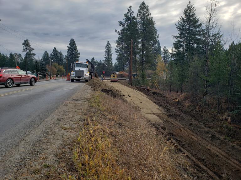
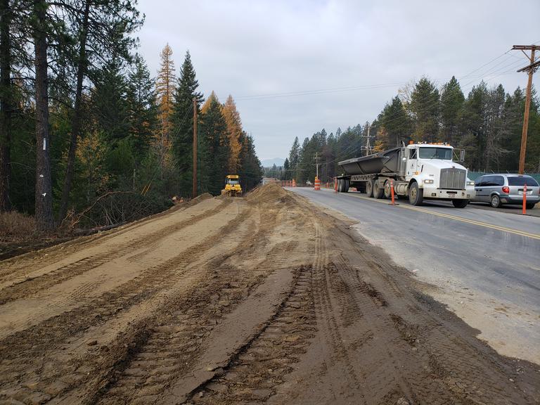
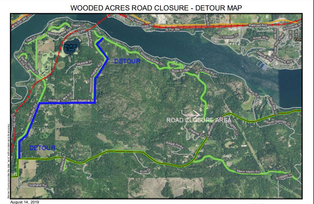
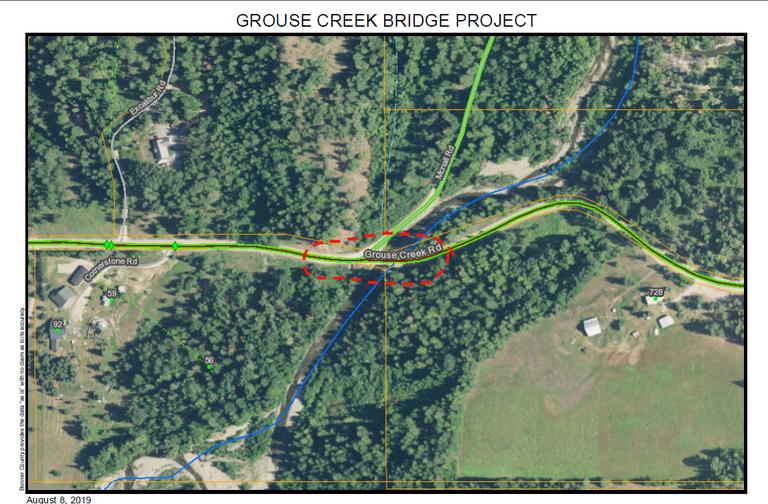


.png)
.png)
.png)
