Road Projects
Road Projects 2026
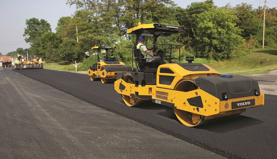
Paving Projects:
District 1 (South of the Long Bridge area):
Clagstone Rd - 6/10/26 UPDATE: Due to the high amount of traffic, we will be closing Clagstone Rd in the section between Als Welding Rd and Pinehaven Rd while we rebuild for asphalt starting on Monday, June 15th from 7am - 3pm. We will only allow local traffic and emergency vehicles through, otherwise there will be detours in place. 6/9/26: We will be starting our paving project on Clagstone Rd on 6/9/26. We will be starting at the end of the pavement near Kelso Clagstone Cutoff on Clagstone Rd and head west approx. 5.5miles to Highway 41, including Clagstone Cutoff. We will also be paving the aprons of the following intersections: Blanchard Cutoff, Als Welding Rd, Pinehaven Rd. Please expect delays. We will keep the road open as much as we can, but we may intermittently have to close the road, there will be detours in place during those closures.
District 3 (Sandpoint - Clark Fork area):
Trestle Creek Federal Lands Project FLAP - Paving, widening, and creating pullouts every 1000ft for passing purposes for Trestle Creek Road from Hwy 200 to the snowmobile parking area (appx 3.8 miles from HWY 200).
7/14/26 Update: MJ Hughes is scheduled to perform work on Saturday, July 18th and Saturday, July 25th. As a result, Trestle Creek Road will experience single-lane closures between 8:00 AM and 6:00 PM, with anticipated traffic delays of up to 30 minutes.
A Note from the Western Federal Lands Highway Division:
"Western Federal Lands and its General Contractor, MJ Hughes, will begin road construction work along Trestle Creek Road (Forest Road NF-275), between Mileposts 0.0 to 3.7, starting May 21, 2026 and running until November 5, 2026.
The road remains open to local traffic. During active construction (Monday–Friday), motorists should expect single lane closures with delays of up to 30 minutes between 8:00 a.m. and 6:00 p.m. Emergency vehicles will be accommodated immediately at all times.
No construction delays will occur on weekends (Friday 6:00 p.m. through Monday 6:00 a.m.) or during Memorial Day, Independence Day, or Labor Day holiday weekends. Flaggers and pilot cars may be in operation during daytime hours. Motorists are advised to obey all posted signs and allow additional travel time
The impacts allow for the improvement of Trestle Creek Road, by stabilizing eroded banks, installation of new drainage structures, and allowing for a new paved roadway. Thank you for your patience during construction."
Magnesium Chloride:
District 1 (South of the Long Bridge area): Complete
(In no particular order, and not every road is done in its entirety) Al's Welding Rd, Bandy Rd, Beers Humbird Rd, Blacktail Rd, Blanchard Cutoff, Butler Creek Spur, Curtis Creek Rd, Davis Rd, Deer Trail Rd, Eureka Rd, Edgemere Cutoff, Evergreen Rd (Sagle), Fish Creek Rd, Garfield Bay Cutoff, Geaudreau Ln, Golden Gate Rd, Granite Loop, Gun Club Rd, Gypsy Bay Rd, Hawthorne Dr, Heath Lake Rd, Herrmann Lake Rd, Hoo Doo Mountain Rd, Jewel Lake Rd, Kelso Lake Rd, Kendal Rd, Little Blacktail Rd, Martin Bay Rd, Mays Rd, Mountain Ash Dr, Mountain View Rd (Blanchard), Overlake View Rd, Otts Basin Rd, Poirier Rd, Railroad Ave (Blanchard), Roberts Ln, Roop Rd, Rusho Ln, S Santiago Rd, Santa Claus Ln, Saunders Rd, Southside School Rd, Sunset Rd, Swan Shores Dr, Talache Loop, Talache Rd, Teal Ln, Trails End Rd, Twin Rivers Rd, W Garfield Bay Rd, Walker Rd, Westwood Heights Rd, Willow Bay Rd.
District 2 (Priest Lake - Priest River area): Complete
(In no particular order, and not every road is done in its entirety) 1st St in Priest Lake, 2nd St in Priest Lake, Albeni Cove Rd, Anselmo Ln, Barrett Rd, Bear Paw Rd, Blackthorn Rd, Blue Lake Rd, Cambell Loop, Carr Creek Rd, Clinton Ave, Cork Rd, Diamond Heights Rd, Dinger Rd, E Settlement Rd, E Thama Dr, Eastriver Loop, Eastriver Rd, Eastside Cutoff, Eastside Rd, Elder Rd, Elkins Rd, Endicott Loop, Fox Creek Rd, Freeman Lake Rd, Gleason-Mcabee Falls Rd, Granite Creek Marina Rd, Groves Addition, Hagman Rd, Helen Thompson Rd, High Circle Rd, Holley Glen Cutoff, Holley Glen Rd, Holley Glen W, Icehouse Rd, Jachetta Cutoff, Jachetta Rd, Jim Low Rd, Johnny Long Rd, Langille Canyon Rd, Manley Creek Rd, Moore Loop, Mountain Creek Rd, N Parkwood Dr, N Riley Creek Rd, Old Thama Ferry Rd, Parley Ln, Peninsula Loop, Peterson Rd, Poverty Valley Rd, Reeder Creek Rd, Rena Rd, Reynolds Ln, S 1st St (Priest River), S 2nd St (Priest River), S Granite Bay Rd, Sanborn Creek Rd, Santa Maria Rd, Scotts Rd, Shady Pines Loop, Shaw Rd, Shelby Rd, Sherwood Beach Rd, Springdale Gardens, Sundance Loop, Squaw Valley Cutoff, Squaw Valley Rd, Tanglefoot Trl, Thama Dr, Timber Ln, W Lakeshore Rd, W Settlement Rd, Williams Dr, Womack Rd.
District 3 (Sandpoint - Clark Fork area): Complete
(In no particular order, and not every road is done in its entirety) Baldy Mountain Rd, Cabinet Gorge Rd, Center Valley Rd (95-S Center valley), Derr Rd, Dry Creek Rd, E Spring Creek Rd, Elmira Rd, Evergreen Rd, Forest Siding Rd, Gold Creek Rd, Gooby Rd, Grouse Creek Cutoff, Grouse Creek Rd, Hickey Rd, Hidden Valley Rd, Hopkins Rd, Johnson Creek Rd, McGhee Rd, Meadowood Rd, Miramount Beach Rd, Mountain View Dr, Mosquito Creek Rd, N Boyer Rd, N Center Valley Rd, Old Highway, Painter Rd, Park Ln/Shadow Mountain Rd, Providence Rd, Racetrack Rd, Rapid Lightning Rd, Selkirk Rd, Shepherds Ln, Sunnyside Cutoff, Sunnyside Rd (backside), Trestle Creek Rd, Upper Gold Creek, W Elmira Rd, W Selle Rd, W Shingle Mill Rd, W Spring Creek Rd, Winterton Rd, and the Clark Fork Boat Station.
.png)
Chip Seal Projects:
District 1 (South of the Long Bridge area):
Glengary Bay Rd to Sagle Rd, Sagle Rd to Garfield Bay Rd, Garfield Bay Rd to Sagle Rd, Sagle Rd to Gold Mountain Rd, Gold Mountain Rd to Sagle Rd, Sagle Rd to Lignite Rd, Lignite Rd to Sagle Rd, Sagle Rd to Highway 95.
District 2 (Priest Lake and Priest River area):
Bayview Dr, Eastriver Rd (North End), Substation Cutoff, Missouri St, Freeman Lake Rd, Hoo Doo Loop, Hoop Loop, Silver Birch Ln, Spring Haven Dr, Merritt Ln, and Larch St.
District 3 (Sandpoint/Clark Fork area):
Leisure Ln and Serinity Pl, Crooked Ln, Mountain View Dr, Woodland Dr, Vedelwood Dr, N Boyer Rd, W Bronx Rd, Providence Rd, Center Valley Rd, Grouse Creek Cutoff, Colburn Bridge, Samuels Rd and Grouse Creek Bridge and Grouse Creek intersection, Elmira Rd.
.png)
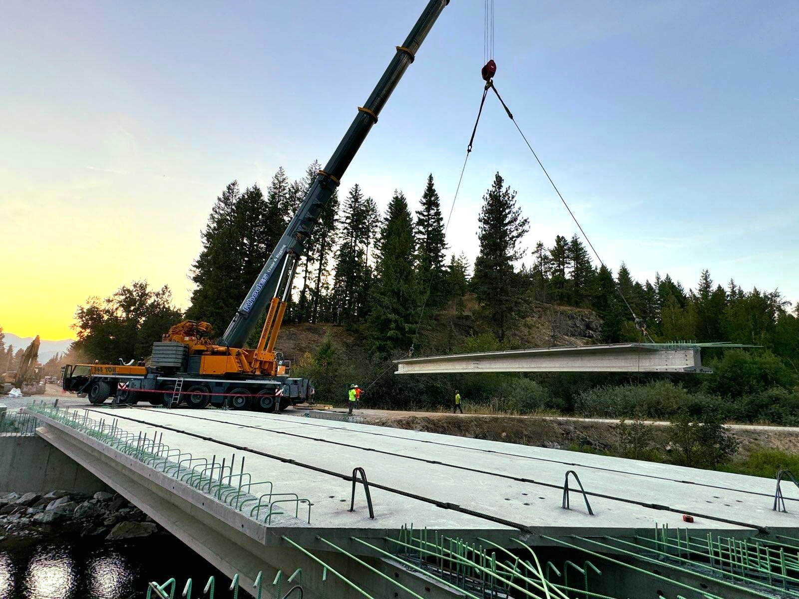
Bridge Projects:
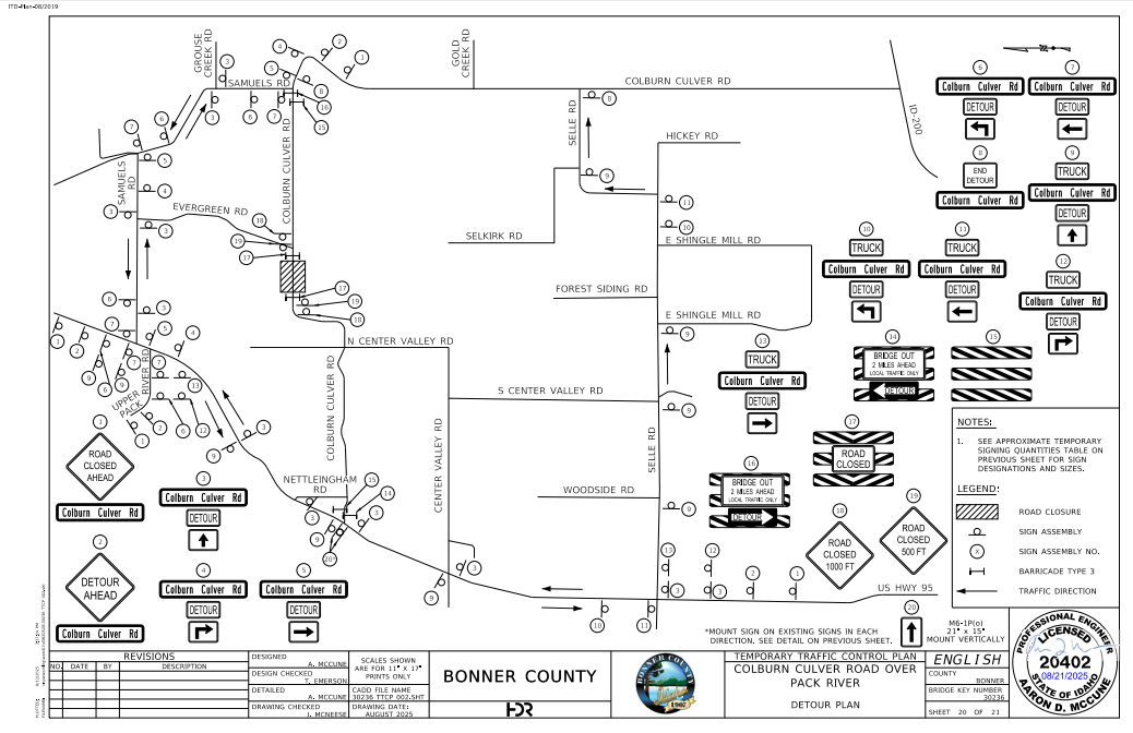
Colburn Culver Over Pack River (between Selkirk Rd and Evergreen Rd) - The work began on Monday, March 30th, 2026. The bridge will be closed to all traffic but there are detours in place:
Rapid Lightning Bridge #4 - Construction to begin Summer 2026.
Eastshore Rd Over Hunt Creek - 5/21/26 Update: Hunt Creek Bridge is now open. There will not be any more night closures this week. Eastshore Rd will be closed at the Hunt Creek Bridge from 5/20 - 5/22 from the hours of 6PM to 6AM. Please Plan accordingly. J7 Contracting will begin construction on Eastshore Rd over Hunt Creek Bridge near Coolin ID. Traffic control will be in place with single lane closure and single lane traffic. The construction will begin on April 1, 2026, and go until September 16, 2026.
Cocolalla Creek Bridge (near Quinns Ln on Cocolalla Loop) - 6/17/26 Update: The North Entrance of Cocolalla Loop Rd will be closed at the Cocolalla Creek Bridge on Wednesday, June 24th for bridge repairs. This should only be a single day closure. Please use the South entrance as an alternate route.
Merrit Bridge - Pilling Wrap Repair and Deck Epoxy 2028 or beyond.
Whiskey Jack Bridge - We were awarded a grant for this project. Construction to begin 2029 or beyond.
Eastriver Loop - Currently under design stage.
Striping Projects:
District 1 (South of the Long Bridge area):
Bayview Rd, Blacktail Rd, Blanchard Elk Rd, Bottle Bay Road, Clagstone Rd, Sagle Rd, Spirit Lake Cutoff, Tweedie Rd.
Railroad Crossing Crossbucks and Stop Lines: Edgemere Cutoff and Sagle Rd.
District 2 (Priest Lake and Priest River area):
Bodie Canyon Rd, Cavanaugh Bay Rd, and Eastshore Rd.
District 3 (Sandpoint/Clark Fork area):
River Rd and Colburn Culver Rd.
Railroad Crossing Crossbucks and Stop Lines: Elmira Rd (1st RRX, BNSF), Elmira Rd (2nd RRX, Union Pacific RR), Kootenai Bay Rd, North Boyer Rd, Samules Rd (BNSF crossing by Hwy 95) and Samules Rd (UPRR crossing)
Culvert Projects:
Clagstone Rd - In preparation for paving, culverts will be replaced throughout the road on Clastone Rd from Highway 41 to Kelso Clagstone Cutoff - Summer 2026.
Melody Ln - A Concrete Box Culvert will be installed beneath Melody Ln - Summer 2026.
River Rd - There will be a culvert replacement on River Rd near Cabinet Gorge Rd - Summer 2026.
Other Projects:
Spirit Lake Cutoff Curves - Realigning the curves in the road by Beare Rd to make speed appropriate.
Trestle Creek Federal Lands Project FLAP - Paving, widening, and creating pullouts every 1000ft for passing purposes for Trestle Creek Rd from Highway 200 to snowmobile parking lot (approx. 3769 Trestle Creek Rd). The USFS will also have their own project going and will be utilizing the snowmobile parking lot for construction equipment parking. Trestle Creek Road from Hwy 200 to the snowmobile parking area (appx 3.8 miles from HWY 200) will be closed to public traffic from May 21st to November 5th. Expect thirty-minute delays for local traffic between 8 a.m. and 6 p.m
A Note from the Western Federal Lands Highway Division:
"Western Federal Lands and its General Contractor, MJ Hughes, will begin road construction work along Trestle Creek Road (Forest Road NF-275), between Mileposts 0.0 to 3.7 , starting May 21, 2026 and running until November 5, 2026.
The road remains open to local traffic. During active construction (Monday–Friday), motorists should expect single lane closures with delays of up to 30 minutes between 8:00 a.m. and 6:00 p.m. Emergency vehicles will be accommodated immediately at all times.
No construction delays will occur on weekends (Friday 6:00 p.m. through Monday 6:00 a.m.) or during Memorial Day, Independence Day, or Labor Day holiday weekends. Flaggers and pilot cars may be in operation during daytime hours. Motorists are advised to obey all posted signs and allow additional travel time
The impacts allow for the improvement of Trestle Creek Road, by stabilizing eroded banks, installation of new drainage structures, and allowing for a new paved roadway. Thank you for your patience during construction."
Railroad Projects:
W Selle Rd / N Boyer Rd Crossing - A new crossing arm will be installed by the RR.
River Lake Dr Crossing - A new crossing arm will be installed by the RR.